 |
 |
||||||||||||||||||
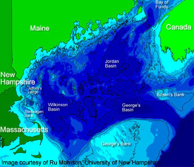
The Gulf of Maine's coastline has shifted significantly
landward and seaward through geologic history. This is because sea
level has risen and fallen through time, mostly because of the freezing
and melting of glaciers. Also, the "land level" has risen
and fallen. This is because as glaciers form, they "press down
on" or depress the land; as glaciers melt, the
land "bounces back" up. |
|||||||||||||||||||
Think about this... Examine the connection between Maine's landforms and the Gulf of Maine's bathymetry. Why can you find marine fossils on land? |
|||||||||||||||||||
|
|||||||||||||||||||