Here are some brief instructions on how to
navigate your way through this investigation:
- Use the arrows -
in the upper right hand corner allow movement
forward and backward through the investigation, next and back at
the bottom of the page will do the same
- Click on the image -
Following this link will take you to an enlarged, and in
most cases, a labeled version of the image.
- Rollover images - change or highlight features
by simply rolling over them.
- Don't miss the Image
Library - a
complete collection of all the pictures you see in this program
and hundreds more!
At the bottom of the page you'll find additional links:
-
Site
Map provides
a table of contents for each topic discussed and
direct links to those topics.
- Help will
bring you back to this page from anywhere in the investigation.
- Teacher
Resources is a link
that teachers can visit to find worksheets, activities
and further discussion of topics
|
|
Who am I?
|
 |
The Shoreline
Profile in the upper
left corner will indicate what zone you are in as you move
through the investigation. By clicking on it, you can return
to the beginning of the zone, or it may take you to a profile
that allows you to choose the zone. |
|
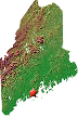
The Maine Map is a reference you can
click on to identify the location where landscape pictures
of the rocky shore were taken. Along with the location, the
type of wave action and exposure will be described as well
as directions to its location. |
|
The film icon provides a
direct link to the Image Library so that users can find similar
or additional images from a particular zone. You'll find this
icon at the end of each zone discussion. |
Comments and questions may be sent to mitzi@bigelow.org |
|
This program is made possible by
the support of the Maine
Sea Grant College Program and the Davis Family Foundation
|