 |
 |
||||||||||||||||||
|
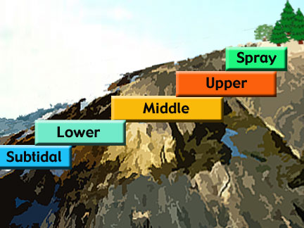
There are few features of the shore that are more obvious then the horizontal bands or zones that appear with the ebbing or falling tide. Coastal shores all over the world have some zonation of the organisms that live there. Zones vary depending on the tidal height so areas with a low tidal range may display narrow bands and areas, like Maine, with high tidal range have wide zones. The diagram above is a general illustration of the location of the five major zones found on the rocky shore. We will describe each zone in detail later on. To go directly to a specific zone now, click on the color bars in the image above. Two scientists, Thomas A. Stephenson and Anne Stephenson were pioneers of the "universal" or general scheme of zonation. For over 30 years, they studied intertidal areas all over the world. They determined that there are 5 major zonation patterns that can be applied to all shores. They present their zonation patterns not in terms of the tides, but in relation to other factors such as light, moisture level, and wave action. Tides do not specifically create intertidal zones, but do highlight the zonal patterns that are defined by the distribution of organisms. |
|||||||||||||||||||
More
on tides... Twice a month, during the time of full and new moons, the spring tides occur. They have the highest high tides and the lowest low tides. Neap tides occur during the first- and third-quarter moons resulting in moderate changes in tide height. A high or low tide will be fifty minutes later the following day. |
|||||||||||||||||||
|
|||||||||||||||||||