 |
|
Climate, which is basically long-term weather, has changed noticeably in the past century. In fact, global average temperatures over the last hundred years have risen about 1°C (>>>).
- Half of this increase occurred in the 1980's. The warmest year was 1990. But then a few years of cooling followed, due to the eruption of Mount Pinatubo in the Philippines which sent volcanic dust into the upper atmosphere, partially blocking sunlight. The heat returned in 1994, it was then the fifth warmest year of the century.
Climate on Earth has changed over the past tens of thousands of years. Evidence of this includes:
- Significant global temperature shifts as seen in ice-core data (shown
above, ^^^).
- Before 20,000 years ago, the temperature often rose and fell abruptly.
- This is shown by the dark blue line plotted between 1950 - 2300 meters depth (right half of graph).
- Some evidence indicates that global temperature changed more than 6°C (10°F) in periods as short as 20 years!
- Before 20,000 years ago, the temperature often rose and fell abruptly.
- Geologic "clues":
- Remnants of glaciers in areas now too warm to support them (for example, Maine's landscape)
- River channels buried under thick sand deposits in northern Africa.
These data indicate this now harsh desert was once a lush, vegetated
region.
- This evidence was collected by a radar instrument that flew onboard the Space Shuttle. Its radar waves penetrated dry sand to "see" the buried channels below. This and other radar images are available at NASA/Jet Propulsion Laboratory's "Imaging Radar" website.
Climate changes can also raise and lower global sea level. These factors can contribute:
- Thermal expansion of the existing ocean water by climate warming
- Some evidence indicates that increased greenhouse gases could contribute to
- Changes in seawater volume. This can be caused by:
- formation of destruction of large inland lakes (e.g., the "Great Lakes")
- glacial and interglacial periods
- During relative cold glacial periods, vast volumes of seawater can be "tied" up in ice caps and sheets. At these times, large continental areas can be covered by glaciers.
- Conversely, during relatively warm interglacial ("between glacial") periods -- such as now -- most ice sheets and large glaciers are found near Earth's poles.
- Changes in the "holding" capacity (or volume) of Earth's ocean basins
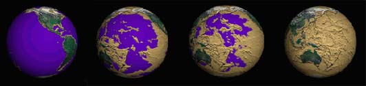
Although climate change is not likely to "drain our oceans," let's examine Earth's coastlines if our ocean basins were "drained." This is done using "data visualization."
- The levels to which the oceans are "drained" in this series of images: 200 meters, 4000 meters, 5000 meters, and completely.
- Note that each subsequent frame shows Earth rotated slightly eastward.
- Click here to see an "animated gif movie" of this sequence. These images and animation are available from NASA/Goddard Space Flight Center's Scientific Visualization Studio website
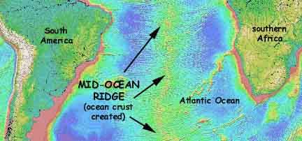
- Mid-ocean ridges (<<<) mark where molten rock -- magma --flows up from depth and pushes the seafloor apart.
- Deep-ocean trenches occur where seafloor is "lost" by sinking. These trenches are often next to arc-shaped chains of volcanoes, such as seen in the Pacific (>>>).
- These bathymetry maps are from the "Measured and Estimated Seafloor Topography" website.
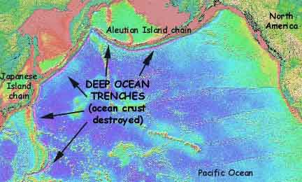

In this scenario (>>>), the ocean basin WIDTH between two continents can remain constant. This is because, in this case, the seafloor "added" at a ridge could be equally "subtracted" at a trench.

- Look at the ice core data presented above. Focus
on the data from less than 1600 meters depth (far left of the graph).
- To what time in history do these data correspond? (Refer to the yellow arrow at bottom.)
- Were these years relatively warm, cold, or average?
- Do these data indicate a connection between climate and the development of human culture?
- How might future signifcant changes in climate affect humans?
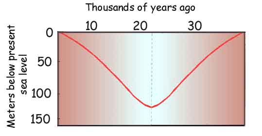
- Seawater volume has fluctuated worldwide between glacial and interglacial periods. The changes in volume have caused corresponding shifts in sea level.
- Can you guess about how much sea level changed during the last major glaciation (over about 35,000 years)?
- Do you think sea level changed by centimeters, meters or kilometers? Click here to see how sea level has fluctuated in the Gulf of Maine, for example.
- What affect would such sea level changes have on Earth's coastlines?
- Plate tectonics describes the process by which Earth's crust moves along its surface. The crust made up of many semi-rigid plates that interact to build the features on land and on the seafloor. ("Tectonics" is from the Greek word "tektonikos" which means "to construct.")
- Given that continents and oceans have shifted position over geologic time, how might this affect the volume of Earth's ocean basins?
- The volume of Earth's ocean basins depends on how quickly seafloor crust is created at mid-ocean ridges or lost at deep trenches
- Look at the ocean basin cross-section or "side
view" (provided above).
- Can you guess why this is the case?
- Do these bathymetry data indicate that the Atlantic Ocean basin is staying at a constant width?
- If not, is the Atlantic widening or narrowing over geologic time?
- Do you think that the Atlantic has always been the
same width?
- To help answer, you may wish to visit the "Measured and Estimated Seafloor Topography" website to see detailed bathymetry for the entire North Atlantic Ocean.
6. When lava flows under the sea, its outer "skin" is instantly frozen to form a solid rind of volcanic glass. As the lava continues to flow, it breaks outs of its shell, exposing fresh lava to the seawater and forming a new glass rind. The resulting lava consists of a pile of lumpy structures called "pillow lavas" because of their shape. Pillow lavas form with their rounded, "puffy" side up.
- This August 1993 photo (right, >>>) of a fresh lava flow was taken with a remotely operated submarine vehicle on a mid-ocean ridge.
- Click here to see the movie (MPEG format).

- Click here to see a photo taken near the border of Canada and western Maine, about 130 miles inland from the Atlantic Ocean. In this photo, ancient pillow lavas can be distinguished by their oval outlines.
- The original tops of the pillows face toward the right. This shows that the earth's crust has been deformed, tilting these rocks on their side.
- Can you guess how these pillow lavas, which were
formed at or near a deep-sea volcano, found their way to northwestern Maine?
- [HINT: Look at the "side view" diagram of an ocean basin shown earlier. Think about where "pillows" might form.]
- [ANOTHER HINT: Big structures, like volcanoes, tend to not want to sink into trenches. Instead, they often get "plastered" onto continents.]
- Learn more about submarine volcanoes from the National Oceanic & Atmospheric Administration (NOAA) / Pacific Marine Environmental Laboratory's VENTS Program website.
- See other great geology images at the Maine Geological Survey's "Photo Gallery" website.
 |
|
|
|

 |
|
