|
Geological History, Landforms &
Coastlines
|
||||||||||
|
|
|
|
|
|
|
|
|
|
||
 |
|
The Association of American State Geologists website provides great links to geological information in 50 states.
- To access the "State Index," click on any state on the U.S. map or the name of your state of interest.
- Near the top of each page, you'll see a link to that state's geology-related
web site. The names of these organizations vary from state-to-state: some
are called "Geological Surveys," others are "Geological
Commissions," etc. You may have to "click around" to find
the right spot!!
- For example, if you click on Maine, you'd see a link to the Maine Department of Conservation "Natural Resources & Information Mapping Center" website. From there you'd click on the Maine Geological Survey
At many of these state geologic survey websites, you can access maps and photos. For example, the Maine Geological Survey has many great images available at their "Photo Gallery" website (>>>).
- From their on-line "Fact Sheets", you'll discover that the geologic history that is recorded in Maine's bedrock covers close to 1.5 billion years -- about one-third the total age of the earth.
Earth's age (about 4.6 billion years) is divided into distinct time units, mostly based on the plant and animal fossils that are found in layers of rock.
- The longest division of geologic time is an eon. Throughout
Earth's history there have been only two eons:
- Phanerozoic (younger)
- Precambrian (older)
- These eons are subdivided into shorter eras:
- Phanerozoic
- Cenozoic (youngest)
- Mesozoic
- Paleozoic
- Precambrian
- Proterozoic (youngest)
- Archaean
- Hadean
- Phanerozoic
- A geologic period is shorter than an era.
- An epoch is the shortest division of geologic time. For example, a geologic period generally contains two or more epochs.
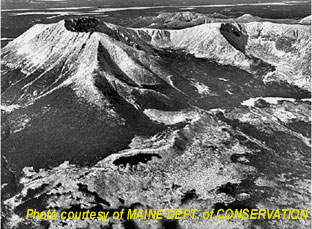
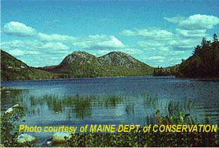
Landforms we see today -- such as Maine's highest terrain at Mt. Katahdin (<<<) -- are usually the result of much more recent processes.
- For example, during the Pleistocene Epoch -- from about 10,000 years to 1.5 million years ago -- Maine's existing moutains and valleys were literally "scraped over."
- This poweful force transported rock debris for miles. Stream patterns
were disrupted and hundreds of ponds and lakes were created. The sand, gravel,
and other sediments that cover much of Maine are largely the product of
this process.
- Some of the landforms that resulted from this "scraping" action are shown at left (<<<).
Another consequence of geologic processes is the shaping of our coastlines. This can be seen in more images (VVV) from the Maine Geological Survey.
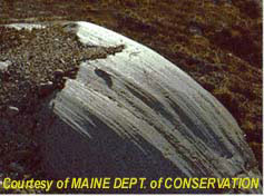
- The left image (VVV)
shows an example of a rocky coast.
- The rugged relief is a result of bedrock surface structure. Surf action has removed any traces of soil.
- The black staining -- mostly from microscopic plants called "algae" -- shows the range from high to low tide in this area.
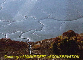
- Also below, the right image (>>>) shows an example of a tidal
flat.
- A network of tidal channels are seen within the gray mud. Bedrock
is not exposed in this tidal flat.
- Tidal flats host many animals, including soft-shelled clams which are harvested commercially.
- Like the rugged rocky coast, where the water meets the tidal flat (in other words, the shoreline) varies with local tides. During high tide, the entire mud flat is covered by water!
- A network of tidal channels are seen within the gray mud. Bedrock
is not exposed in this tidal flat.


- Consider the photos and descriptions of the "sculpted" landforms given above.
- Can you guess what "powerful force" shaped many of Maine's landforms back in the Pleistocene epoch?
- Have landforms in your state of interest been shaped by the same "powerful forces"? Can you guess why or why not?
- Maine's surface rocks are up to 1.5 billion years
old. This span of time covers four geologic eras (Cenozoic, Mesozoic,
Palaeozoic, and Proterozoic). However, most of the landforms seen in
Maine were shaped within the last 1.5 million years, spanning ONLY TWO
EPOCHS.
- Over what percentage of these rocks' "lifetimes" were they shaped into their present form?
- Does this answer surprise you?
- If you could choose an area in your state and divide "age of landforms" by "age of rocks that make up those landforms," do you think the ratio would be higher or lower than that of Maine? Why?
- Even though you may not have heard of the "Mesozoic
Era," you may be familiar with a geologic period within this era known
as the "Jurassic."
- What was "special" about the Jurassic Period?
- Was it before, during, or after the Pleistocene Epoch?
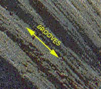
- What is the relationship between the rock's grooves and the "groovy" landform topography along Maine's coast?
- Assuming it has not moved since its grooves were formed, which way do you think this rock is oriented?
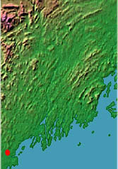
Now examine the shape of Maine's coastline (>>>). [Click here to view a topographic map of the entire state of Maine.]
- Based on what you've learned about coastline shape above, do you think that most of Maine's coast is composed of rugged bedrock or relatively smooth tidal flats?
5. The shoreline examples given above show that the shape of Maine's coastline results from the BALANCE between the relief (or slope) of the shore and local water levels.
- To learn more about this, print the "rugged
coast" image from above (a black-and-white version is OK). Using
the top of the black algae staining as a guide, trace the expected coastline
at high tide.
- How does the shape of your "high tide" coastline compare with the low tide coastline (i.e., that already shown on the "rugged coast" image)?
- Are these shapes significantly different from one another?
- Print the "tidal flat"
image from above (a black-and-white version is OK).
- Trace the expected coastline at high tide.
- From this image, can you determine the shape of the coastline at low tide? Why or why not?
- Which area would show a more dramatic change from high-to-low tide: the rocky coast or the tidal flat?
- How is this related to local relief (or slope)?
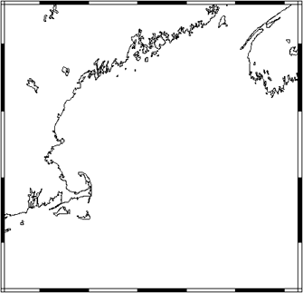
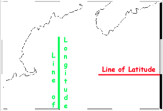
6. If your state of interest has a coastline, you should access the U.S. Geological Survey's "Coastline Extractor" website. It allows the user to create a data file or an image of any coastline in the world.(The "hands-on" activity "Extracting A Coastline" will help you navigate this site. You may also want to try Learning About Map Projections, as well.)
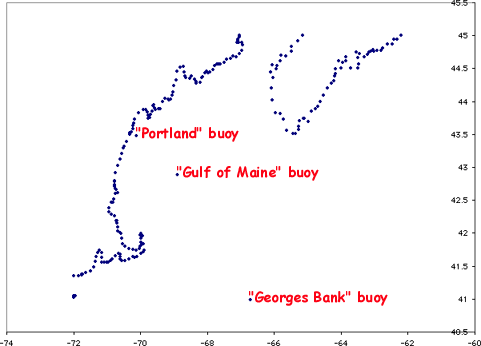
- To check whether your state's tidal range -- or distance between high and low tides -- is large enough to significantly change the coastline's shape; Go to our "Coastal Tides" section to discover where these on-line data are found.
 |
|
|
|

 |
|

|
|
|
|||||||||