| |
PROCEDURE
|
|
Background
- Latitude is relative to Earth's equator. In terms of degrees
latitude, north of the equator is positive and south is negative.
- Longitude is relative to zero degrees, along which Greenwich,
England is located. The International Date Line is located half-way
around the world (i.e., 180 degrees away) in the Pacific Ocean.
|
|
| |
|
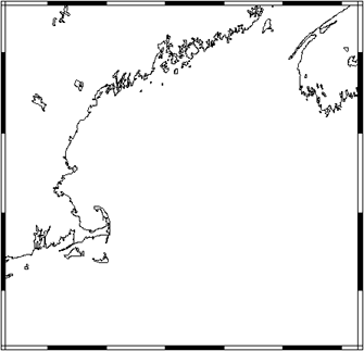
Activity - Step 1 "Visit Website
& Enter Data"
1. Visit the "Coastline
Extractor" website ("Preview" at right
>>>).
2. Choose the area of your map under "Geographic Range
of Extracted Coastline."
3. Type in the northermost latitude as "45".
4. Type in the westernmost longitude as "-72".
Note that for this map-making tool, negative longitude is
west of Greenwich
5. Type in the easternmost longitude as "-62".
6. Type in the southernmost latitude as "40".
7. Using the "pull down menu" under "Coastline
data base," choose the option: "WCL
(World Coast Line) (designed for 1:5,000,000)"
8. Leave the rest of the "clickable" buttons alone
9. Hit "SUBMIT" to "extract the coast."
|
|
Questions - Step 1
- Based on these coordinates, is your map
going to be:
- North or south or the equator?
- West or east of Greenwich, England?
- West or east of the International Date Line?
|
|
| |
|
Activity - Step 2 "Extract Coastline
Data"
1. After you've hit "SUBMIT," you may get a "warning
message" that says "Any information that you submit
is insecure..." Hit "OK" to continue.
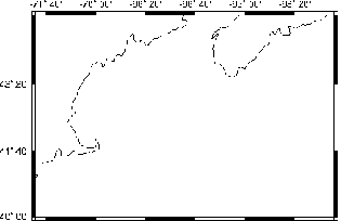
2.Your map will appear as an image on top. (See example at
right >>>.)
3. Latitude and longitude data, formatted as two columns,
are called "XXXX.dat." Note that "XXXX"
is a number generated by the program itself.
|
| Extracted Coastline Data
|
|
|
|
Here is
the coastline data you extracted: XXXX.dat (4650
bytes).
Note: If
you don't want to list the file to your screen, you
might want to select "load to local disk" (or the equivalent)
before selecting. In Netscape, this is accomplished
by holding down the shift key while you click.
|
|
Questions - Step 2
- The scale tells you how the size of
any feature compares to its real size. A map with a scale of 1:12
would be one-twelfth the area of the map's coverage zone. On such
a map each square-inch would represent only one square-foot...
this is not a very practical scale for large areas. To show a
larger area, a map's scale needs to be smaller than
1:12. Think of 1:12 as the ratio 1/12. Any number larger
than 12 will give a ratio that's smaller than 1:12.
- Would you rather be given 1/12th of a medium pizza or 1/100th
of a medium pizza?
- Would you rather split your lottery winnings with 12 people
or 100 people?
- A map's scale is usually quite small in order to show
large areas. For example, to fit the state of Maine (30,995
square miles) on a typical road map, the scale needs to be around
1:679,000.
- Can you approximate what the scale of a road map of Alaska
(570,833 square miles) might be ? How about Rhode Island (1,054
square miles)?
- The file that you generated is from the "World Coast Line"
data set and is good for maps with scales of about 1:5,000,000.
The "World Data Bank II" data set is appropriate for
making maps with scales of about 1:2,000,000.
- The map you made using the "World Coast Line (WCL)"
data base has 220 coordinates (i.e., 220 latitude / longitude
pairs).
- On the other hand, the same area mapped using the "World
Data Bank II" data base has almost 10,000 coordinates.
Click here to see this map.
- Do the coastlines look the same?
- Which has more detail?
- Which data set might be easier to work with?
- These images demonstrate the "trade-off" between
the size of the data set and the relative detail of the data.
- What type of user might prefer the "World Coast Line"
data set?
- What type of user might prefer the "World Data Bank
II" data set?
|
|
| |
|
Activity - Step 3
"Download Coastline Data"
There are two simple ways to dowload these data:
1. Click on the link "XXXX.dat" and the
data will appear on the screen. From here you can copy and
paste onto your own harddisk.
- This is the top instruction given (shown at right >>).
2. Hold down your shift key while clicking on the link "XXXX.dat".
A "pop up" menu should appear that says "Save
this link as..." You may want to change the name of this
file from "XXXX.dat" to "coast.dat".
- This is the bottom instruction given (shown at right >>).
|
| Extracted Coastline Data
|
|
|
|
Here is
the coastline data you extracted: XXXX.dat (4650
bytes).
Note: If
you don't want to list the file to your screen, you
might want to select "load to local disk" (or the equivalent)
before selecting. In Netscape, this is accomplished
by holding down the shift key while you click.
|
|
|
|
| |
|
Activity - Step 4
"Import Data into a Plotting Program"
1. Load your latitude and longitude data into an X-Y plotting
application. Open the application first and then import the
data. [Note that the numbers shown at right will not necessarily
match the ones you import.]
For this area's data, each column has a specific data format:
- LEFT: 10 characters
- RIGHT: 9 characters
- "Tab-delimited" (i.e., columns are separated
by tabs)
2. Knowing these two facts about data format, you should
be able to pull these numbers into your X-Y plotting program
without "breaking up" the data incorrectly.
- For example, if you just looked at the 2nd line of data:
You might think that the first column had 3 characters
and your other column had 9 characters. If you assumed this
and formatted the rest of your data accordingly, your data
would look like**:
|
|
-65 |
43.699862 |
|
| |
-65 |
.09886 |
43.735619 |
| |
-65 |
.131715 |
43.745007 |
| |
-65 |
.232629 |
43.705111 |
|
| Data
table will look like: |
|
|
|
Questions - Step 4
- Look at the data columns (and ignore lines
with "# -b").
- Which column has latitude data?
- Which column has longitude data?
- Are the data sorted in any way?
- Let's say you "mis-sorted" your
data as shown above** and you interpreted
the first column as longitude, the second column as latitude,
and "threw away" the third column.
- About where would your "mis-sorted
coastline" (i.e., bold numbers) be found?
- You may notice that there is room for
an "extra" character in each column: The left column
could hold up to 11 characters and the right up to 10 characters.
- Can you think of any geographic location
that might use all possible characters in these columns?
|
|
| |
|
Activity - Step 5 "Sorting Coastline
Data"
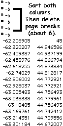
1. You'll notice that some lines have only one entry: "#
-b". These are page breaks and not part of the coordinate
data set. It is recommended that you remove these page breaks
as follows:
- Select both columns of data. This will ensure that
the coordinate pairs do not get separated from one another.
- Use the "sorting" function to sort the left-hand
column into descending (or decreasing) numbers. By doing
this, all the page breaks should end up at the top.
- Delete all the lines that contain page breaks (should
be about 6).
- The "leftover" data will be used to made a map.
|
| Data
table will look like: |
|
|
|
Questions - Step 5
- If the data in the left column are sorted
into descending (or decreasing) numbers, then why is "62"
above "63"?
|
|
| |
|
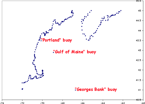
Activity - Step 6 "Creating an X-Y
Plot"
1. Plot the data as an "X-Y scatter plot." The
lefthand column should be plotted along the horizontal ("X")
axis and the righthand column data along the vertical ("Y")
axis.
- The "X" and "Y" axes are also known
as the "abscissa" and "ordinate," respectively,
in the Cartesian coordinate system.
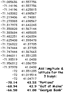
2. At this point, you can also easily add your own data points.
For example, you can add coordintes that show the locations
of buoys in the Gulf of Maine.
- To prepare your map for the buoy data, add the following
three coordinates to data base:
|
|
-70.14 |
43.53 |
|
| |
-68.94 |
42.9 |
|
| |
-66.58 |
41.08 |
|
3. Your map will look something like the plot (without the
buoy names marked) shown below VVV:
|
 |
 |
|
Questions - Step 6
- The term "aspect ratio"
refers to the relationship between the width and the
height of a rectangular image or map. For example,
you may notice that when a few movies are shown on
television there is a black strip at the top and bottom
of the image. This is done to provide a match between
the viewing area of your television's screen and the
aspect ratio of a movie theater's screen.
- The the aspect ratio of
a typical television screen (light blue) and that
of a typical movie screen (dark blue) are represented
in the image below (VVV).
- Which has a higher
width-to-height, or aspect, ratio?
|
- Compare the aspect ratio of
your "X-Y" plot*** with the one created
within the "Coastline Extractor" website.
(For example, for each map measure 10 degrees longitude
and 5 degrees latitude. Then calculate the ratio for
each map.)
- Do the two charts have
the same aspect ratio?
- If not, which map more closely
represents the way your coastline really
looks?
- How do you know what the coastline really
looks like?
***If you did not created your own"X-Y" plot,
use the example "X-Y" plot
above.
|
 |
|
2.
The
"Coastline Extractor"-generated map is in
a format called "Mercator projection." This
is a common way to represent our "3-D" globe-shaped
Earth on flat, two-dimensional map.
- Click here to learn more
about Mercator Projection maps.
|
|
|
|
EXTENSION
|
|
| |
VOCABULARY
- aspect ratio:
the proportion between its longer and shorter sides of a rectangle;
for example, the aspect ratio of a square is 1:1.
- coordinates: any of a set of magnitudes by means of which the
position of a point, line, or angle is determined with reference to
fixed elements.
- latitude: location on Earth's surface based on angular distance
north or south of the equator. Equator, 0°; North Pole, 90°N;
South Pole, 90°S.
- longitude: distance (expressed in degrees) east or west of
the prime meridian, along which Greenwich, England is located. The International
Date Line is 180° away from the prime meridian.
- scale: the proportion that map, etc. bears to the thing it
represents (e.g., a scale of one inch to a mile).
|
|
