| |
INVESTIGATIONS
|
|
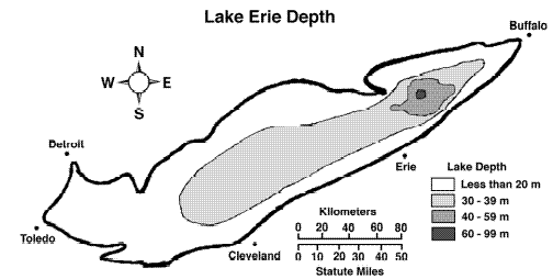
- With an average depth of less than 20 meters (65 feet), Lake
Erie is the shallowest of the Great Lakes. According to the map
labeled Lake Erie Depth, the west basin of
Lake Erie is (deeper) (shallower) than the east basin.
- In general, shallower areas of a lake store less heat, cool
off faster in autumn, and are usually the first to form ice in
winter. From Lake Erie Depth map, it seems
likely that winter ice would first from in the (east) (west) basin.
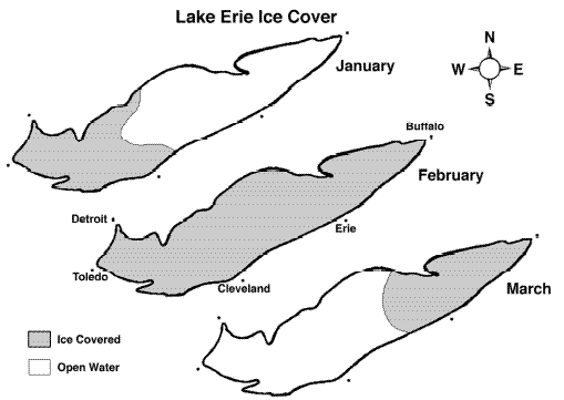
- Check your prediction by comparing the depth map with the long-term
average ice cover maps for January and February. For Lake
Erie, the ice cover begins in the (deeper) (shallower) basin and
spreads to the (deeper) (shallower) basin.
- In general, the deeper areas of a lake are the last to form
ice in winter and the first to lose ice in the spring. But for
Lake Erie, with the prevailing wind blowing from southwest to
northeast along the length of the lake, floating ice is transported
to the (eastern) (western) basin.
- According to the ice cover diagrams, Coast
Guard ice breaking assistance would most likely be required for
ships attempting to transport cargo in the eastern basin of Lake
Erie between the ports of Erie, PA and Buffalo, NY in early (January)
(March).
- A lake-effect snow is a highly localized fall of snow immediately
downwind from an unfrozen lake. It occurs, in part, because of
the energy and moisture that the open lake waters add to the cold
air blowing across it. Because winds during lake-effect snows
often blow from the west, the roads most likely to be closed by
lake effect snows are those between (Detroit and Toledo) (Erie
and Buffalo).
- The formation of an insulating ice cover limits the transfer
to the air of the energy and moisture that is necessary for the
development of lake-effect snow. Based on the ice cover maps for
January and February, of the two months, the one with the greater
potential for lake-effect snow is (January) (February).
|
|
|
|