
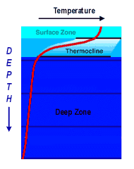
Temperature versus Depth
The sunlit and wind-driven upper layer of Earth's oceans rests on relatively colder and denser waters. At times, there is a distinct temperature difference between the wind-stirred Surface Zone and the quieter Deep Zone below. Such a drop in temperature with depth is shown in red at left (<<<). Although temperature generally decreases with depth, there is a layer where temperatures drop abruptly called the Thermocline. In the Gulf of Maine, the thermocline is usually shallower than 50 meters.
Click here to see a "CTD" instrument that scientists use to measure temperature at various depths.


Hands on activities (include Standards & Benchmarks):
With no external forces applied, the ocean would stratify into a simple layered structure based on its density (mass divided by volume). Factors that influence seawater's density are:
- Pressure (which is related to water depth);
- Temperature; and
- Salt content (or salinity).
When heated, seawater volume expands and density decreases. So, Sun-warmed surface waters generally float on top of colder, denser waters below. This leads to layering of water -- or stratification -- by temperature. However, stratificiation can be "undone" by other forces including wind and tides.
In the Gulf of Maine, waters are mixed by wind and tides and only stratify under certain conditions and at certain times of the year. That is why our researchers plan to take measurements in the Gulf of Maine during three seasons.
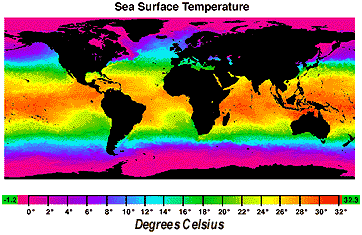
Sea Surface Temperature
Without ocean currents, sea surface temperatures would depend only on latitude with the bands of warmest waters located along the equator. Because ocean currents transport heated water around the globe, the distribution of sea-surface temperatures is more complicated (VVV).
Click here to access the latest data from the Gulf of Maine (part of the Gulf Stream image).