|
OVERVIEW
Much of the ocean has a layered temperature structure. Thermal layers
may be revealed by measuring the change in the temperature of seawater
from the surface down to the ocean bottom. The following activity uses
a set of temperature versus depth measurements, called temperature profiles,
for three different latitudes. These profiles help reveal the general
layered thermal structure of the ocean
OBJECTIVES
After completing this activity, you should be able to:
- Describe the layered temperature structure of the ocean.
- Describe the variation with latitude of the ocean's thermal layers.
INVESTIGATIONS
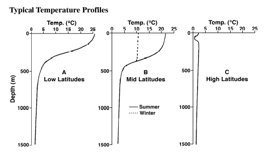
- Examine the temperature profile for the low latitudes labeled "A".
The depth is in meters (m) and the temperature is in degrees Celsius
(°C). The warmer water is found near the (surface) (bottom).
- Most of the sunlight entering the ocean is absorbed very near the
surface. This sun-warmed surface water mixes with cooler, deeper waters
as winds, breaking waves and turbulent currents stir the water. One
result of this mixing is a surface layer having nearly uniform temperature,
or isothermal, conditions. This layer is called the mixed
layer. On the low-latitude profile, the mixed layer extends a depth
of (less than 500 m) (1,000 m) (4,000 m).
- The temperature of seawater immediately below the mixed layer changes
rapidly with depth. This layer of rapid temperature change extends down
to about 1,000 m and is called the main thermocline. As the depth
increase within this layer, the temperature (increases) (decreases).
- The main thermocline separates the warmer mixed layer above from
the cooler deep layer below. In the deep layer, the water is
almost isothermal, with only a gradual decrease in temperature to the
ocean floor. The top of this deep layer is found at a depth of (less
than 1,000 m) (more than 1,000 m).
- Examine the temperature profile for the mid-latitudes labeled "B".
This profile resembles the low-latitude profile but with some important
differences. Compared to the low-latitude profile, the mixed layer temperature
is (cooler) (warmer) and shows (seasonal variation) (no seasonal variation).
- Now examine the temperature profile for the high latitudes labeled
"C". Compared to the low and mid-latitude profiles, the surface
temperature is (cooler) (warmer) and a strong (isothermal) (thermocline)
situation exists at these latitudes.
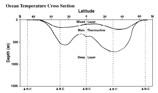
- Now examine the ocean temperature north-south cross-section that extends
from about 70° south latitude to 70° north latitude. At the
bottom of each vertical dashed line in this diagram, circle the letter
A, B, or C indicating which of the three temperature profiles you would
expect to find at that particular latitude.
- The accumulation of ocean temperature measurements from a variety
of locations and depths has revealed that there is a three layered thermal
structure in most of the ocean. In the warmer low and mid-latitudes,
a main thermocline layer with rapidly changing vertical temperature
separates the warmer surface mixed layer from the colder deep layer.
Although this colder deep layer is found at all three latitudes, it
extends essentially to the surface only at (low) (mid) (high) latitudes.
|