 |
|
The Applied Physics Lab (APL) at Johns Hopkins University has a great website with color-coded maps of sea surface temperature. These data are from a satellite instrument called "AVHRR," which is an acronym for Advanced Very High Resolution Radiometer.
- "Radiometer" comes from the words "radiation" and "measure."
- The radiation being measured is heat.
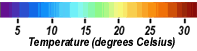
- The "color bars" (at right, >>> and below, VVV)
are show how colors relate to temperatures (in degrees Celsius).
- For every temperature map that you examine, be sure to check the color bar!
- Maps are available for various areas, including:
- Gulf of Mexico
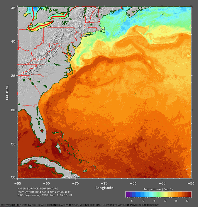
- Gulf
Stream (see example at right, >>>)
- Click here to learn more about the Gulf Stream from satellite images (Courtesy of the Univ. of Rhode Island)
At APL's website, you will see a list of months beginning with late 1996. (Note that not all months listed have data.) Available maps show data that are averaged over 3 days or 7 days.

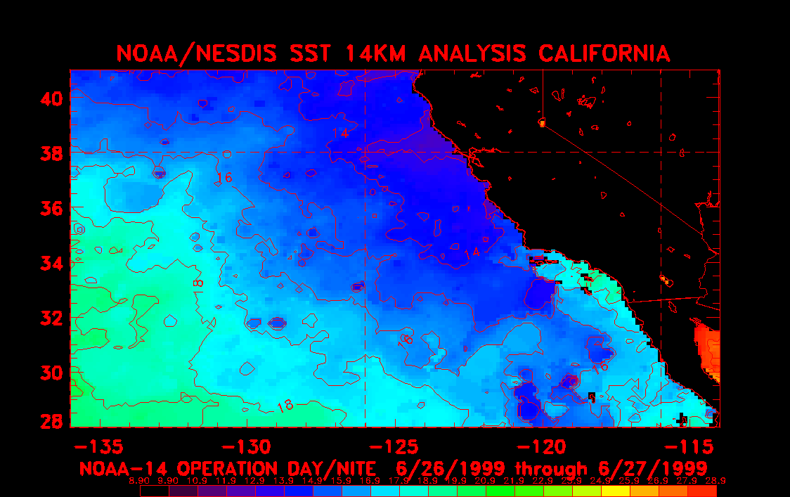
At left (<<<) is an example of such a map from off California's coast. Note that the land areas are colored black.
Click on any of the following links to see the latest sea surface temperature data off of these U.S. coasts:
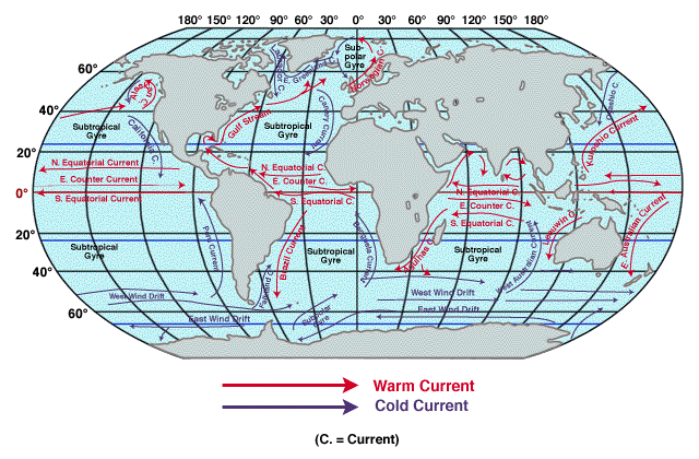
Oceanographers use maps of sea surface temperature to see how shallow currents travel the globe.
- Click on map at right (>>>) to see a simplified view of warm and cold surface currents.
- Compare this map with the two sea surface temperature images above (^^^).
- You can also compare this map to NOAA's latest on-line map of global
sea surface temperature.
- Do warm and cold current arrows shown at right (>>>) match the sea surface temperature data?
So, why is heat transfer by ocean currents important?
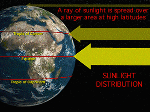
Consider that because Earth is round, it is heated unevenly by sunlight.
- The equator is relatively hot because sunlight strikes Earth directly at that latitude;
- At the poles, the Sun's energy that strikes Earth is spread over a larger area (<<<).
The oceans and atmosphere transfer heat around the globe and thus moderate our long-term weather (climate). For example, ocean currents generally move heat toward the poles and cold away from the poles (see map above, ^^^).
To better understand why Earth's oceans and atmosphere are important for moderating overall temperature, consider the planet Mars.
Liquid water is not stable on Mars' surface because:
- it has a very thin atmosphere with a surface pressure less than 1% that of Earth; and
- its temperature is very cold
On Mars, water exists only as ice and vapor, much as carbon dioxide does on Earth (dry ice and carbon dioxide gas).
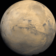
Daily temperature swings on Mars' surface tend to be very large, except in polar regions where ice caps stabilize temperature. In non-polar regions, night-to-day temperature swings of 80 degrees Celisus (or 144 degrees Fahrenheit) are common. In part, this is because of the very thin atmosphere, which does not trap heat very well.
- The large swings in Martian temperature reflect the low heat capacity
material of its surface material.
- Heat capacity is the amount of heat required to raise the temperature of 1 gram of any substance by 1 degree Celsius.
- Click here to see a map that shows the
difference in heat capacities of Earth's ocean water and its continental
rocks.
- Areas that show very little difference in temperature from night-to-day are colored white.
- Areas that show very large differences in temperature from night-to-day are shown as red.
 |
- Look again the map that shows
the difference in night-to-day temperatures of Earth's surface material.
- On this map, which type of "surface material" is primarily colored white?
- Which type of "surface material" is
primarily colored red on this map?
- What does this tell you about the heat capacity of rocks / soil versus that of water? In other words, which type of material "holds heat" better?
- Think more about how well different materials "hold
heat," but on a smaller scale.
- Imagine that a 4-quart metal pot with wooden handle that is half-filled with water is brought to a boil.
- With the heat off, predict when you'd feel comfortable
touching the materials listed (just below). For each case would you: "Touch
it immediately," "Wait a few minutes," or "Wait a
while"?
- Metal rim of the pot, well above the water line;
- Side of the pan below the water line;
- Air located one centimeter above the water;
- Air located one meter above the water;
- Wooden handle;
- Water in the pan.
- Based on your answers, predict how well does each of these "hold heat"? Metal, air, wood, water.
- This "mental exercise" involves not
only the heat capacity of materials, but how well each transfers heat.
For example, where/when you'd be comfortable touching the metal part of
the pot probably depends on whether it is in direct contact with the hot
water.
- Metal is a good conductor of heat,
which means metal heats up quickly. Is the opposite true, as well?
In other words, does metal cool down quickly when its heat source
is removed?
- Is air a good conductor of heat? How about wood? Water?
- Metal is a good conductor of heat,
which means metal heats up quickly. Is the opposite true, as well?
In other words, does metal cool down quickly when its heat source
is removed?
- You've learned that ocean currents distribute heat
from low latitude (e.g., the equator) to high latitude (e.g., the Arctic
and Antarctic).
- Consider two U.S. cities that are at about the
SAME latitude: San Franciso, CA and Norfolk, VA.
- Would you expect these cities to have approximately
the same month-to-month temperatures?
- Why or why not?
- Would you expect these cities to have approximately
the same month-to-month temperatures?
- Click here to see
a graph showing their monthly temperatures. One city's temperature range
is shown as an orange line with triangles, the other city's month-to-month
temperatures are shown as a grey line with circles.
- Which line shows Norfolk's temperatures? Which line belongs to San Francisco?
- Perhaps the maps of coastal water temperatures of (1) the California Current and (2) the Gulf Stream will help you answer this question.
- To check your answer, you may wish to
access "Normal Mean Temperature" (in degrees Fahrenheit)
for many U.S. cities by
clicking here.
- The cities are listed in alphabetical order BY STATE.
- Note that the first column of this chart shows that the climate data have been collected over many (usually 30) years, the last column shows the normal ANNUAL mean temperature, and the middle 12 columns are January through December.
- Use an atlas to find other pairs of U.S.
cities with about the same latitude, one on the west coast and the
other on the east coast. Examples include San Diego, CA and Charleston,
SC; and Eureka, CA and New York City, NY.
- For each city, find the monthly temperature data from the "Normal Mean Temperature for many U.S. cities" website.
- Plot these data on a graph, similar
to the graph for San Francisco and
Norfolk.
- Are your results similar? Can you guess why or why not?
- Consider two U.S. cities that are at about the
SAME latitude: San Franciso, CA and Norfolk, VA.
4. Ocean water is marked by its saltiness, or "salinity."
Salinity is calculated as the amount of salt (in grams) dissolved in 1,000 grams of seawater. Thus salinity is often expressed as "parts per thousand" (ppt).
The salinity of near-surface ocean water varies from place to place.Surface ocean salinity ranges from about 32 ppt in the northernmost Pacific to 37.5 ppt in the central north Atlantic (>>>).

Compare the map of ocean surface salinity (^^^) with the latest on-line map of global sea surface temperature.
- Is there a GENERAL correlation between relatively high salinity (teal green, orange, brown in the map above, ^^^) and sea surface temperature?
- Is there a GENERAL correlation between relatively low salinity (dark and light blue in the map above, ^^^) and sea surface temperature?
To better understand some of the DIFFERENCES between sea surface temperature and its salinity, here are some physical process that affect salinity at the ocean surface, some of which are not temperature-related:
- Evaporation at the surface of the ocean leaves surface water more saline because salt molecules, being relatively heavy, do not easily rise into the air.
- The crystal structure of ice cannot hold much salt, therefore when water freezes, the surrounding liquid water becomes more saline.
- Seawater salinity decreases when fresh water (salinity = 0) enters the ocean. Fresh water comes into the ocean primarily as rain and snow, and runoff from rivers and melting ice.
- Many regions are affected by processes that both increase and decrease salinity. For example, near the margins of continents, dry winds blow off landmasses and increase salinity via high evaporation. In these same areas, salinity is decreased by the influx of freshwater from nearby rivers.
- In general, the higher ocean salinities occur in the centers of ocean basins, where trade winds evaporate water and rain is rare.
Learn more about salinity and water from these "Hands on" activities:
 |
|
|

 |
