 |
|
The "water cycle" describes the movement of water from the oceans to the atmosphere to the continents and back to the sea. Click here to see an animation of this process (1 MB)
"Runoff" describes water that moves over the land's surface. It can flow over the surface in many ways: from tiny trickles to raging rivers.
Precipitation -- rain, snow, etc. -- is the only source for runoff. However, not all preciptiation ends up as runoff... much of it is lost to the atmosphere via:
Hydrologists, those who study water, are very interested in how rivers flow. So they measure "discharge": the rate of water flow in a river channel.
- Discharge is the volume of water passing through a cross-sectional area of river over time.

- The image above (^^^) shows a vertical "cut" through -- or cross-sectional area of --the two hills and river valley.
- The cross-sectional area of the river is estimated by multiplying its
width by its mean depth.
- To better understand what "mean depth" means, consider this
group of depths (in feet) taken across a river: 45, 67, 85, 79, 87,
100, 99, 98, 92, 91, 100, 91, 90, 88, 87 , 85, 85, 80, 76, 72, 66.
- Of these 21 values, which would you say is the "middle" depth?
- If you chose 83.95 as the "middle" depth, you picked a value
known as the "mean." It is calculated by adding the
21 depths together and then dividing the total by 21.
- Based on "Muddling about the Middle" from the University of Illinois at Urbana-Champaign Office for Mathematics, Science, and Technology Education website.
- If you chose 83.95 as the "middle" depth, you picked a value
known as the "mean." It is calculated by adding the
21 depths together and then dividing the total by 21.
- Of these 21 values, which would you say is the "middle" depth?
- To better understand what "mean depth" means, consider this
group of depths (in feet) taken across a river: 45, 67, 85, 79, 87,
100, 99, 98, 92, 91, 100, 91, 90, 88, 87 , 85, 85, 80, 76, 72, 66.
- The mean velocity cannot be measured at a single place, it is usually determined from many points within a stream.
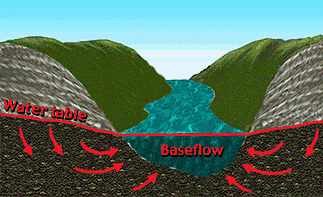
Typically, the "top" of a river is where water table intersects the stream channel (shown at left, <<<).
- Within the stream, this is called the "baseflow" and is supplied by groundwater flow (red arrows at left, <<<).
When the water supply to an area is relatively low, river discharge will be mainly baseflow, supplied by groundwater.
- If such dry conditions persist, the baseflow will decline and the water
table will drop.
- An example of this is presented below (VVV).
Changes in the water table position are color-coded as follows:
- July 1st in red
- July 8th in yellow
- July 15th in green
- An example of this is presented below (VVV).
Changes in the water table position are color-coded as follows:
- As this occurs, the elevation of the water surface -- or river stage -- also drops.
- The graph below (VVV) shows the river stage "dropping" over a period of two weeks.

[Much of this information is dervied from "Landscape: an Introduction to Physical Geography" by W. Marsh & J. Dozier, 1981, Addison-Wesley Publishing Co., Inc., Library of Congress Catalog Card No. 80-68120, ISBN-0-201-04101-4.]
The National Weather Service and National Oceanic and Atmospheric Administration) provides on-line river stage data for most of the U.S.
- Their on-line "clickable map" will lead you to river condition
information for your area.
- For example, the Northeast River Forecast Center collects data from 100 locations throughout New England and New York.
- Some -- but not all -- of these River Forecast Centers have near-real-time
interactive "River Stage" or "River Condition" plots.
- Click here to see hourly "River Stage Plots" for some areas of New England
- Here are some keywords that may help you find these resources at the River Forecast Center near you: "Current River Stage Data" or "Real-Time" or "River Information" or "Streamflow Data."
The U.S. Geological Survey's "Real-Time Water Data" webage provides hydrologic information about the nation's water resources. You can access data from rivers near you by using the "clickable U.S. map" or clicking on your state's name. Below (VVV) is an example from the Kennebec River Basin (Maine) for July 27 1998.
| Maine Current Streamflow Conditions |
| Select a station number to view graph(s) and other data for the station. |
| Kennebec River Basin |
| Station Number |
Station Name |
Long-term
median flow 07/27 |
Flow
|
Stage
|
Date & Time |
| 01042500 | Kennebec R at The Forks |
2700
|
6630
|
5.43
|
07/27 12:30 |
| 01046500 | Kennebec R at Bingham |
3360
|
7160
|
8.82
|
07/27 12:30 |
| 01047000 | Carrabassett R nr N. Anson |
151
|
254
|
3.50
|
07/27 14:00 |
| 01048000 | Sandy River near Mercer |
175
|
292
|
3.43
|
07/27 13:00 |
| 01049000 | Sebasticook R nr Pittsfield |
216
|
102
|
1.80
|
07/27 14:00 |
| 01049205 | Kennebec R near Waterville |
7410
|
6130
|
13.81
|
07/27 13:30 |
| 01049320 | Kennebec R. at Augusta |
--
|
--
|
-0.33
|
07/27 13:29 |
| 01049500 | Cobbossee Str. at Gardiner |
230
|
100
|
3.11
|
07/27 14:00 |
Click on "Station Number" to find:
- "Streamflow (discharge) versus time" graph
- "Stage versus time" graph
- "Station Description"
- "Location"
- "Drainage area"
- "Period of record" (time this station has recorded data)
- "Gage" (type used)
- "Remarks"
- "Daily Mean Flow Statistics" (for that date)
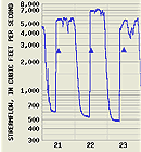
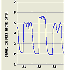
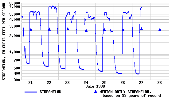
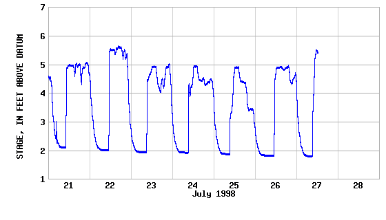
For example, if you clicked on "Station Number 01042500" in the table above (^^^), you'd see graphs like those shown at right (>>>).
- Click here to see how streamflow varied
during the week of 21-July-1998.
- Also shown is the median streamflow value for July 21st...taken over 93 years!
- Click here to see how the river stage varied during that week.
- "Historical Streamflow Daily Values" (as graphs or data tables)
- "Peak Flow" (data tables)
- "Map of region surrounding station"
Water supply to rivers can vary a lot over a few hours, days, or weeks. For example, under wetter-than-normal conditions -- such as sudden storms -- river can temporarily rise above the level of the water table.
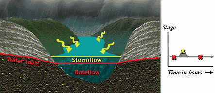
The graph of "Stage versus Time in hours" (at left, <<<) shows how a sudden heavy storm can cause a short-term "peak" in river level (shown as a yellow "X").
In this case, the peak occurs after the rainfall has saturated the soil and continued rain (1) falls directly into the channel and (2) creates runoff that flows downhill into the river channel.
Now consider the "opposite" problem: the prolonged lack of rainfall. Such conditions are of great concern to many, the National Drought Mitigation Center provides an on-line centralized source information about droughtin the U.S. at its "Drought monitor" website.
- Click on words "Drought Monitor" to see the latest map (examples
is shown below,VVV ).
- Yellow (D0): Drought Watch Area (abnormally dry but not full drought status)
- Tans, browns (D1-D4): Current drought ranging in severity from standard (D1) to severe (D2-D3) to extreme (D4)
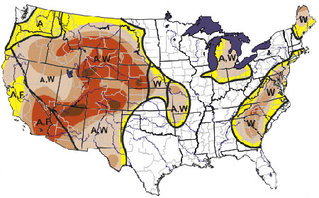
- "A" = agricultural (crops, grasslands)
- "F" = forestry (wildfire, potential)
- "W" = water (rivers, wells, reservoirs)
Under "Current Conditions," this website features maps of recent data for the U.S., including (click on each to see an example):
- Palmer Drought Severity Index example
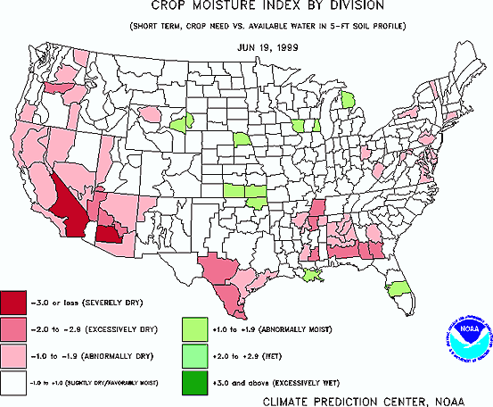
- Crop Moisture Index example
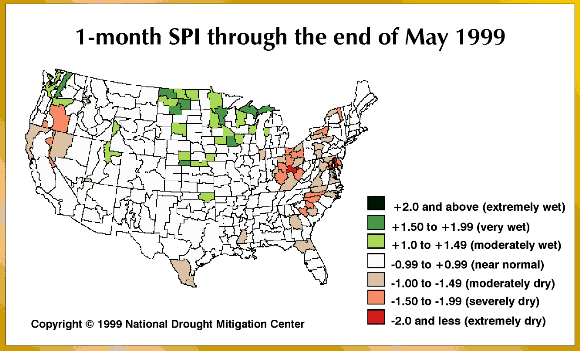
- Standardized Precipitation Index example
- Percent of Normal Rainfall example
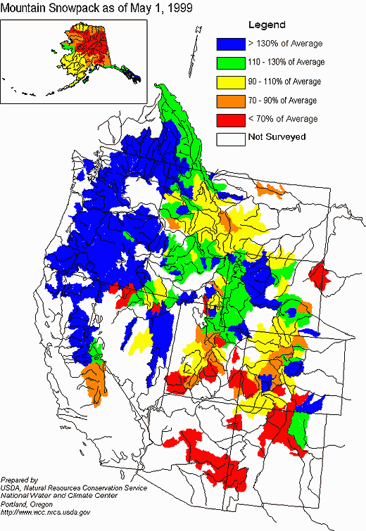
- Snowpack example
- Soil Moisture example
- Vegetation and Temperature Condition Index example
Under "Forecasts," you will find a wealth of forecast maps, as well.
 |
- As stated above, the "mean velocity cannot be measured at a single place, it is usually determined from many points within a stream."
- Why is this the case?
- There are two "example graphs" of river
"Stage versus Time" above (click here to
see one, click here to see the other). Based on these,
can you sketch similar graphs that depict these of the following conditions?
Be sure to choose the appropriate time units for each situation (hours,
days, weeks):
- Streamflow without rain
- Streamflow from weeks-long drought (until the water table drops below the bottom of the stream channel)
- Streamflow from a light rainfall (rain falls directly into the stream channel but no runoff is created)
- Streamflow from a extended (over weeks) drizzle
- Streamflow from a cloudburst
- Streamflow from weeks-long, hard rain
- To better understand what
"median flow" means, consider this group of flow rates (in feet
per hour) taken from a river over time : 45, 67, 85, 79, 87, 100, 99, 98,
92, 91, 100, 91, 90, 88, 87 , 85, 85, 80, 76, 72, 66.
- Rearrange these values in order like this: 45, 66, 67, 72, 79, 76, 80, 85, 85, 85, 87, 87, 88, 90, 91, 91, 92, 98, 99, 100, 100.
- Of these 21 flow rates, which would you say is the "middle" flow rate?
- If you chose 87 as the "middle" flow rate, you picked a value known as the "median." It is obtained by "stripping away" the top 10 rates and bottom 10 rates, leaving "87" as the "middle" one.
- NOTE: These 21 "flow rates" are the
same 21 values used to calculate the "mean depth" above.
Thus the "mean" for these values is 83.95.
- Based on "Muddling about the Middle" from the University of Illinois at Urbana-Champaign Office for Mathematics, Science, and Technology Education website.
- Compare the graph of streamflow during the week of 21-July-1998 with the graph of river stage during the week of 21-July-1998.
- At a glance, how are "streamflow" and
"river stage" related?
- Which is probably easier to measure? Why?
- Compare the relatively "jumpy" graph
of river stage during the week of 21-July-1998 with the smooth "example
graph" of river stage shown above.
- Can you guess why the stage of the Kennebec River at The Forks is so "jumpy" over time?
- Begin at the USGS "Real-Time Water Data" website, click on your state and then select the "Station Number" for a river located near you.
- Look the latest "Stage versus time"
graph (if available).
- Is the graph smooth? "Jumpy"? Trending
down through time? Trending up through time?
- Why might this be the case?
- Is the graph smooth? "Jumpy"? Trending
down through time? Trending up through time?
- The table below (VVV)
has the "Daily Mean Flow Statistics" for the Kennebec River at
The Forks based on 93 years of records for July 27th (data are given in
cubic feet per second).
- Such tables are available for rivers throughout
the U.S. Begin at the USGS
"Real-Time Water Data" website, click on your state and
then select the "Station Number" for a river located near
you. The ""Daily Mean Flow Statistics" table can be found
near the bottom of this webpage.
Latest flow 07/27 12:30MinimumMeanMaximum80% exceedance50% exceedance20% exceedance6,6302172,5104,6401,4802,7003,450Percent exceedance means that 80, 50, or 20 percent of all daily mean flows for 07/27 have been greater than the value shown.
- Can you explain why the "Latest flow"
measured at 12:30 P. M. on 7/27/98 is GREATER THAN the "Maximum
Daily Mean Flow" (which is based on 93 years of records) shown
in the table directly above?
- Does looking at the graph of streamflow during the week of 21-July-1998 help you answer this question?
- The stated "Mean" flow value for July
27th (based on 93 years of records) is 2,510 cubic feet per second.
- How does this compare to the "Median Daily Streamflow" value shown as a triangle on the graph of streamflow during the week of 21-July-1998?
- In this example, are values for the "Mean"
flow (from table) and the "Median" flow (from graph) about
equal? Exactly equal? Not even close?
- Can you explain why?
- Also shown in this table are the 20%, 50%, and 80% "exceedance" values for July 27th.
- Can you guess why this type of information might be useful to hydrologists?
- Click here to access the latest data from this station (#01042500) at Maine's "Current Stream Conditions" website.
- Is today's "Latest flow" data (found
near the bottom of the webpage) much higher, much lower, or about
the same as that of 7/27/98?
- IF there is a significant difference between these two measurements, what factors might be responsible?
- Such tables are available for rivers throughout
the U.S. Begin at the USGS
"Real-Time Water Data" website, click on your state and
then select the "Station Number" for a river located near
you. The ""Daily Mean Flow Statistics" table can be found
near the bottom of this webpage.
- Does the same type of difference exist between
the "Mean Flow" values for these two dates? (In other words,
if the "Latest flow" value from 7/27/98 is much higher than
today's "Latest flow" value, was the "Mean Flow"
for 7/27/98 also much higher than "Mean flow" for today's
date)?
- Considering today's data, how does the value
for the "Mean" flow (from table) compare with the "Median"
flow (from graph)? About equal? Exactly equal? Not even close?
- Can you explain why?
- Considering today's data, how does the value
for the "Mean" flow (from table) compare with the "Median"
flow (from graph)? About equal? Exactly equal? Not even close?
- The "hydologic equation" is:
- Runoff = (Precipitation) minus (Evaporation plus Transpiration) plus / minus (Changes in storage water)
- Storage water is defined as:
- Soil water + groundwater
= the mass of water found in the soil, sand, clay, gravel,
etc. and upper solid rock -- called bedrock -- that underlies
these "loose" materials.
- Do you think that storage water changes
a lot over days? Months? Seasons? Years?
- What factors -- natural or human-induced -- could potentially alter storage water volume over time?
- Do you think that storage water changes
a lot over days? Months? Seasons? Years?
- Soil water + groundwater
= the mass of water found in the soil, sand, clay, gravel,
etc. and upper solid rock -- called bedrock -- that underlies
these "loose" materials.
- All terms in the "hydrologic equation"
are expressed as a volume per time such as gallons per hour.
- Can you name other such "volume per time" units?
- Given that rainfall is usually measured as depth per time (for example, inches per hour), how can you convert this into a volume?
- As shown above, the equation
for discharge is (cross-sectional area) times (velocity).
- What are the units for discharge?
- Are these units the same as those in the "hydrologic equation"?
 |
|
|
|

 |
