|
|
|
|
|
|
|
|
|
|
|
|
|
|
What's A Watershed?
|
|
|
|
|
|
|
|
|
|
|
|
|
|
|
|
|
|
|
|
|
|
|
|
|
|
|
|
|
|
|
|
|
|
|
|
|
|
|
|
|
|
|
|
|
|
|
|
|
|
|
|
|
|
 |
- Find out what you know -- and should know -- about watersheds
- Learn why the state of watersheds is being carefully monitored
throughout the U.S.
|
|
|
|
|
|
|
|
|
|
|
|
|
|
|
|
|
|
|
Background information on watersheds is available from the Conservation
Technology Information Center. "What's
a Watershed?" site helps you better understand. To research your watershed on-line, you'll need
to know your "watershed address."
- Discover your "Watershed
Address" by clicking here.
- Then type in one of these: Zip code, river name, city or county name.
|
|
|
Click on the link to your "watershed address." You will see
a map and links to useful resources.
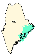
- For example, for the "01050002 Maine Coastal" watershed,
you see these maps that show the extent of your watershed (example at
right, >>>).
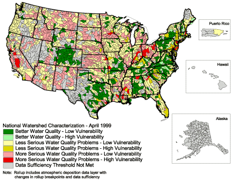
The Environmental Protection Agency has "Index
of Watershed Indicators" for the United States. Click
on the link to "Index
of Watershed Indicators National Maps."
- The "Overall
Watershed Score" is based on many individual indicators within
each watershed.
- To access maps and information available for many indicators, click
the links below:
|
 |
|
|
|
|
|
|
|
|
|
|
|
|
|
|
|
|
|
|
|
 |
- Research
watershed quality in the U.S.
- Discover what factors put our watersheds at risk
- Learn about the "watershed address" system
|
|
- Following the list of weblinks given directly
above, research the "Individual
Indicators" for your watershed.
- Does the result surprise you? If so,
is your watershed "healthier" or "less healthy"
than you thought it would be?
- Which, if any, of these indicators
show healthy conditions in your watershed?
- Which, if any, are rated as problems?
- Can you guess why your watershed
received these ratings?
- Looking beyond your watershed, can
you guess why some watersheds are in worse shape than others?
- Can you think of actions that could improve
your watershed's health?
- Why might (or might not) your community/city/state
wish to take such action?
- Think about a place in the U.S.where environmental
conditions are likely "below average."
- Follow the same process outlined in Question
#1 (just above) for that place.
- Did your results match your expectations?
- Do the same type of research for a place
in the U.S. where you think environmental conditions are likely
to be "above average."
- Did your results match your expectations?
- Do you think that there any single factor
that has the greatest negative impact on our environment?
- Get to know your state's watersheds by
accessing the EPA's "Locate
Your Watershed" webpage. Use their "clickable
U.S. map" to see a watershed map for your state.
- Does the outline of your state's watershed
map look "funny" to you?
- Why or why not?
- Can you name one state whose watershed
map might closely resemble its state outline?
|
|
|
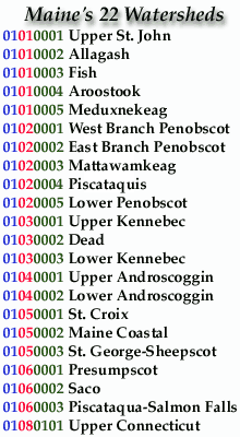
4. Consider that each Maine "watershed
address" begins with "01" as the first two digits
(>>>). This identifies that the watersheds in Maine are
within the "New England" Region.
- The next two digits, however, vary from
"01" to "06" and "08".
- The last four digits vary between "0001"
and "0101".
Find out more about the "watershed addresses"
in your state by accessing the EPA's "clickable
U.S. map."
- Scroll down past the map of watersheds
to see the total number of watersheds in your state. Click on
that number.
- You'll see a list of all the "watershed
addresses" in your state.
- Does each "watershed address"
in your state begin with the same two digits?
- If so, can you guess why?
- If not, scroll through your state's
list and click on one example for each "watershed
address" that begins with a different pair of digits.
- Do the maps of these watersheds'
locations help you to understand how the "watershed
address" system works?
|
 |
|
 |
- designated use
- hydrologic
- indicators
|
|
|
|
|
|
|
|
|
|
|
|
|
|
|
|
|
|
|
|
|
|
|
 |
|
|
|
|
|
|
|
|
|
|
|
|


