|
|
|
|
|
|
|
|
|
|
|
|
|
|
|
|
|
|
|
|
|
|
|
|
|
|
|
|
|
|
|
|
|
|
|
How Buoy Data Change Over Hours
|
|
|
|
|
|
|
|
|
|
|
|
|
|
|
|
|
|
|
|
|
|
|
|
|
|
|
|
|
|
|
|
|
|
|
|
|
|
|
|
|
|
|
|
|
|
|
|
|
|
|
|
|
|
|
|
|
|
|
|
|
|
|
|
|
|
|
|
|
|
|
|
|
|
|
|
|
|
|
|
|
|
|
|
|
|
|
|
|
|
|
|
|
|
|
|
|
|
|
|
|
|
|
|
|
|
|
|
|
|
|
|
|
|
|
|
|
|
|
|
|
|
|
|
|
|
|
|
|
|
|
|
|
|
|
|
|
|
|
|
|
|
|
|
|
|
|
|
|
|
|
|
|
|
|
|
|
|
|
|
|
|
|
|
|
|
|
|
|
|
|
|
|
|
|
|
|
|
|
|
|
|
|
 |
- See a time series of sea data
- What time is "Zulu" time!!!?
- Learn how winds, waves, and the atmosphere are observed by buoys
|
|
|
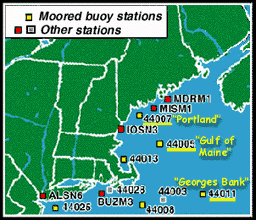
The table below (VVV) shows
a time series of data. In this case, the data "series" has
12 hours of observations from the "Gulf of Maine" buoy.
- NOTE that many buoys DO NOT record all of these different types of data!
Hours are shown in the third column as "Zulu time," which is also
known as Greenwich Mean Time (GMT).
- Greenwich, England is globally accepted as a reference standard for both
time and longitude (its location marks zero degrees longitude). "Zulu"
time is based on a 24-hour clock.
- Click here to check
out how U.S. time zones compare to GMT.
|
|
|
|
|
|
|
|
|
|
|
|
|
|
|
|
|
|
|
|
|
|
|
|
|
|
|
|
|
|
|
|
|
|
|
|
|
Previous 12 observations
| MM |
DD |
HH |
|
WDIR |
|
WSPD |
GST |
|
WVHT |
DPD |
APD |
MWD |
PRES |
|
ATMP |
WTMP |
DEWP |
VIS |
|
PTDY |
| |
|
Z |
|
|
|
kts |
kts |
|
ft |
sec |
sec |
|
in |
|
F |
F |
F |
mi |
|
mb |
| 08 |
05 |
22 |
|
S |
|
1.9 |
1.9 |
|
2.3 |
6.2 |
6.7 |
- |
30.16 |
|
70.3 |
67.8 |
- |
- |
|
-1.2 |
| 08 |
05 |
21 |
|
SSE |
|
1.9 |
3.9 |
|
2.6 |
11.1 |
6.9 |
- |
30.18 |
|
70.5 |
68.5 |
- |
- |
|
-0.7 |
| 08 |
05 |
20 |
|
S |
|
1.9 |
1.9 |
|
2.6 |
6.7 |
6.9 |
- |
30.18 |
|
70.7 |
67.6 |
- |
- |
|
-0.8 |
| 08 |
05 |
19 |
|
- |
|
0.0 |
1.9 |
|
3.0 |
10.0 |
7.7 |
- |
30.19 |
|
70.5 |
67.3 |
- |
- |
|
+0.0 |
| 08 |
05 |
18 |
|
S |
|
3.9 |
3.9 |
|
2.6 |
9.1 |
7.7 |
- |
30.20 |
|
69.3 |
67.3 |
- |
- |
|
+0.0 |
| 08 |
05 |
17 |
|
S |
|
3.9 |
3.9 |
|
2.6 |
11.1 |
7.9 |
- |
30.20 |
|
68.5 |
66.4 |
- |
- |
|
+0.0 |
| 08 |
05 |
16 |
|
SSE |
|
3.9 |
5.8 |
|
2.6 |
10.0 |
7.9 |
- |
30.20 |
|
67.8 |
66.2 |
- |
- |
|
+0.0 |
| 08 |
05 |
15 |
|
SSE |
|
5.8 |
5.8 |
|
2.3 |
11.1 |
7.4 |
- |
30.20 |
|
67.8 |
66.4 |
- |
- |
|
+0.0 |
| 08 |
05 |
14 |
|
SE |
|
3.9 |
3.9 |
|
2.3 |
10.0 |
7.3 |
- |
30.20 |
|
67.8 |
65.8 |
- |
- |
|
+0.6 |
| 08 |
05 |
13 |
|
ENE |
|
3.9 |
3.9 |
|
2.3 |
5.3 |
7.2 |
- |
30.20 |
|
68.5 |
65.8 |
- |
- |
|
+0.6 |
| 08 |
05 |
12 |
|
- |
|
0.0 |
0.0 |
|
2.0 |
7.7 |
6.6 |
- |
30.19 |
|
66.9 |
65.3 |
- |
- |
|
+0.6 |
| 08 |
05 |
11 |
|
NW |
|
1.9 |
1.9 |
|
2.3 |
5.9 |
7.0 |
- |
30.18 |
|
65.8 |
65.1 |
- |
- |
|
+0.0 |
|
|
|
|
The "Previous 12 observations"
may be posted each hour for these measurements:
- WIND DIRECTION (WDIR)
- Average wind direction (degrees clockwise from north) over an eight-minute
sampling time.
- Winds blow FROM the direction listed.
- WIND SPEED (WSPD)
- Average wind speed (knots) over an eight-minute sampling time.
- WIND GUST (GST)
- Peak 5 second gust speed (knots) measured during an eight-minute sampling
time.
- WAVE HEIGHT (WVHT)
- Significant wave height (feet) is calculated as the highest
one-third of all of the wave heights during a 20-minute sampling
time.
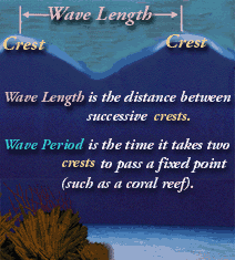
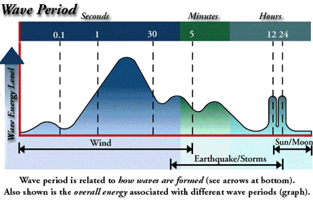
- DOMINANT WAVE PERIOD (DPD)
- Dominant wave period (seconds) is the period with the maximum
wave energy.
- Click here to learn about wave periods.
- Click here to see the relationship
between wave energy and wave period.
- AVERAGE WAVE PERIOD (APD)
- Average wave period (seconds) of all waves during a 20-minute sampling
time.
- ATMOSPHERIC PRESSURE (PRES)
- Sea level pressure (millibars)
- AIR TEMPERATURE (ATMP)
- Air temperature (degrees Fahrenheit)
- WATER TEMPEATURE (WTMP)
- Sea surface temperature (degrees Fahrenheit)
- PRESSURE TENDENCY (PTDY)
- How barometric pressure (millibars) is changing over time (steady,
rising, or falling)
[Learn more about these measurements at http://seaboard.ndbc.noaa.gov/measdes.shtml]
|
|
 |
- Consider how wind, waves and the atmosphere
change over hours
- Are data collected during August 1998 similar to data gathered
today?
- Compare the conditions at three buoys
- Learn the tie between atmospheric pressure systems, wind direction
and weather
|
|
|
|
|
|
|
|
|
|
|
|
|
|
|
|
|
|
|
|
|
|
|
|
|
|
|
|
|
|
|
|
|
|
|
|
|
- Look at wind data in the table
above (WDIR, WSPD, GST).
- Which measurement showed the most variability
(or tendency to change)?
- During any of these 12 observations, were the
wind gusts very different from the average wind speed?
- Can you guess why or why not?
- How do these data compare to the latest
data for the "Gulf of Maine" buoy?
- How do you explain the differences between the
data above (from August 5, 1998) and the latest data?
- Seasonal changes? Storm activity?
- How do the latest 12 hours of wind condition
observations at the "Gulf of Maine" (or
any other) buoy compare with those from:
- Look at the wave data in the table
above (WVHT, DPD, APD).
- Which measurement showed the most variability
(or tendency to change)?
- During any of these 12 observations, was the
Dominant Wave Period (DPD) very different from the Average Wave Period
(APD)?
- Can you guess why or why not?
- How do these data compare to the latest
data for the "Gulf of Maine" buoy?
- How do you explain the differences between the
data above (from August 5, 1998) and the latest data?
- Seasonal changes? Storm activity?
- How do the latest 12 hours of wave observations
at the "Gulf of Maine" (or
any other) buoy compare with those from:
- In the table above, the last
four columns with data are related to atmospheric conditions (PRES, ATMP,
PTDY) and water temperature (WTMP).
- Consider the barometric pressure-related data
(PRES, PTDY).
- Earth's average sea level pressure is 29.92
inches of mercury.
- Is pressure at the "Gulf of Maine"
buoy on August 5, 1998 higher or lower than Earth's average?
- How do the latest readings from the
following stations compare with Earth's average pressure for
:
- Look at the "Pressure Tendency"
(PTDY) over the 12-hour observation period in the
table above.
- Was pressure generally steady, rising,
falling, or a combination of these?
- How do the latest Pressure Tendency
readings compare with:
- Compare the air temperature (ATMP) and water
temperature (WTMP) readings in the table above.
- Which was generally warmer?
- Would you expect air temperature to ALWAYS
be warmer than water temperature?
- Look at the latest air and water temperature
readings for:
- Changes in our weather are usually tied to shifts
in low and high pressure systems. Because the U.S. is in the northern hemisphere:
- High-pressure systems (H) = Winds circulate
clockwise
- Low-pressure systems (L) = Winds circulate
counterclockwise
- Look at the latest "12 observations"
of wind direction (WDIR) for either the "Gulf
of Maine" buoy or the "Georges
Bank" buoy or
a buoy located nearer to you. Draw a series of arrows that show
how winds shifted over the previous 12-hour period (recall that
"WDIR" shows the direction from which the winds
were blowing).
- Were winds generally circulating clockwise,
counterclockwise, or neither?
- Is the wind circulation pattern consistent
with the pressure data for this buoy?
- Repeat this process for the "Portland"
buoy.
- Are these wind data consistent with
those at the other buoy you chose?
- If not, can you explain the differences?
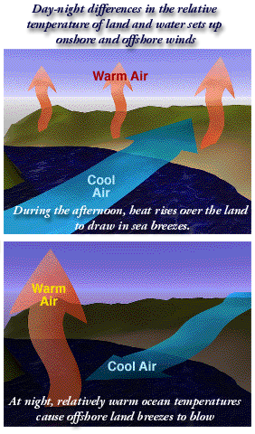
- Think about the
location of the "Portland" buoy (#44007).
- What factors other than
high- and low-pressure systems might strongly affect
winds at the "Portland" buoy?
- HINT: Click
here to see an image representing one possible
factor.
- How might these readings relate to near-future
weather? (Click here to
access a "hands on" activity that will help you forecast weather
based on atmosheric pressure and wind readings.)
|
|
 |
- barometric pressure
- degrees Fahrenheit
- high-pressure systems
|
- longitude
- low-pressure systems
- millibars
|
- significant wave height
- time series
- variability
|
|
|
|
|
|
|
|
|
|
|
|
|
|
|
|
|
|
|
|
|
|
|
|
|
|
|
|
|
|
|
|
|
|
|
|
|
|
|
|
|
|
|
|
|
|
|
|
|
|
|
|
|
|
|
|
|
|
|
|
|
|
|
|
|
|
|
|
|
|
|
|
|
|
|
|
|
|
|
|
|
|
|
|
|
|
|
|
|
|
|
|
|
|
|
|
|
|
|
|
|
|
|
|
|
|
|
|
|
|
|
|
|
|
|
|
|
|
|
|
|
|
|
|
|
|
|
|
|
|
|
|
|
|
|
|
|
|
|
|
|
|
|
|
|
|
|
|
|
|
|
|
|
|
|
|
|
|
|
|
|
|
|
|
|
|
|
|
|
|
|
|
|
|
|
|
|
|
|
|
|
|
|
|
|
 |
|
|
|
|
|
|
|
|
|
|
|
|
|
|
|
|
|
|
|
|
|
|
|
|
|
|
|
|
|
|
|
|
|


