 |
|
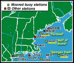
At left (<<<) is a map from the National Data Buoy Center that shows buoy locations off the northeast U.S. There are many buoys off U.S. coasts. We will focus on 3 sites underlined in yellow at left (<<<):
- #44007 "Portland"
- #44005 "Gulf of Maine"
- #44011"Georges Bank"
Buoy data can tell us about these conditions at a specific place:
- Winds at sea
- Waves
- Weather or atmospheric conditions
- Water temperature
At right (>>>) is an example of the Station Information available from the National Data Buoy Center. The location of this buoy is shown on the map above ^^^) .
- The buoy's latitude and longitude are given as 42.90 N, 68.94 W
- Note that the Station number for this buoy is #44005.
There are several instruments on this buoy. Their location on the buoy platform is described alongside the photo.

44005 - GULF OF MAINE 85 NM (Nautical Miles) EAST OF PORTSMOUTH, NH
6-meter NOMAD buoy DACT payload42.90 N 68.94 W
Site elevation:sea level
Air temp height:5 m above site elevation
Anemometer height:5 m above site elev.
Barometer elevation:sea level
Sea temp depth:1m below site elev.
Water depth:29.3 m
Watch circle radius:69 yards
The table at right (>>>) is entitled "Conditions at 44005 as of 2300 Z (7:00 pm EDT) on 08/05/1998." Thus these data show conditions at the "Gulf of Maine" buoy on August 5, 1998.
- "2300 Z"
- This is known as "Zulu time," which is also known as Greenwich Mean Time (GMT). Greenwich, England is globally accepted as a reference standard for both time and longitude (its location marks zero degrees longitude). "Zulu" time and GMT are based on a 24-hour clock.
- "7:00 pm EDT"
- Eastern Daylight Time (EDT) is GMT minus 4 hours (Standard Time is GMT minus 4 hours).
- Click here to check out how other U.S. time zones compare to GMT.
You can learn more about this table n the Buoy Data Formats section.
Conditions at 44005 as of 2300 Z ( 7:00 pm EDT) on 08/05/1998:
| Wind Speed: | 0.0 kts ( 00 m/s) | |
| Wind Gust: | 1.9 kts ( 1 m/s) | |
| Wave Height: | 2.3 ft (0.7 m) | |
| Dominant Wave Period: | 10.0 s | |
| Atmospheric Pressure: | 30.17 in (1021.7 mb) | |
| Pressure Tendency: | -0.0 mb (Steady) | |
| Air Temperature: | 70.5 F ( 21.4 C) | |
| Water Temperature: | 67.8 F ( 19.9 C) |

- Surface measurements from buoys are extremely important for ocean science but are limited as far as area coverage. Look at the map of buoy locations off the U.S. northeast coast.
- How do you think the number of buoy stations compares with the number of weather stations on land?
- Given your answer, do you think that weather on land is better monitored than weather at sea?
- Why do you think this is the case?
- The type of instruments found on the buoy are listed found by clicking here. Consider the following information:
- "Anemos" is Greek for "wind"
- "Baros" is Greek for "weight"
- Which measurements are made by the anemometer? What does the barometer weigh?
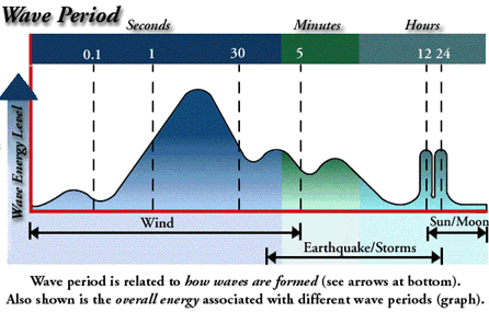
3. The graph at right (>>>) shows the distribution of wave energy in Earth's oceans. The greater the area of the graph means the higher energy level for that wave period.
Blue = wave periods less than 1 minute
Green = wave periods between 1 minute and 1 hour
Greenish-blue = wave periods longer than 1 hour
- What wave-causing force generates the most of the energy possessed by ocean waves?
- Why do you think this is the case?
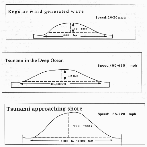
4. A tsunami (pronounced "tsoo-nah-mee") is a seismic sea wave caused by sudden movements of the earth's crust. A tsunami has a very long wave period and over deep water, they can reach speeds of 760 km per hour (470 mph).
- Tsunmais are usually caused by underwater earthquakes.
- Can you think of other events that might cause these long-period waves?
- Click here to see an animation (with narration) about tsunamis (2 MB).
- Click here to see how regular wind waves compare to tsunamis.
5. On the graph above (^^^), the distance between "0.1 seconds" and "1 second" is about equal to the distance between "30 seconds" and "5 minutes." And both of these are much less than the distance between "12 hours" and "24 hours."
- Can you name the type of scale that is being used to show time on this graph?
- Can you guess why this scale is called "non-linear"?
- Why was this scale chosen to show this type of information?
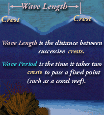
6. Now that you know more about the relationship between wave-generating forces and wave period, let's examine the relationship between wave-generating forces and wave length (>>>).
- Which wave-generating force(s) cause(s) relatively short wave length waves?
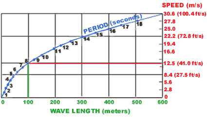
7. For DEEP-WATER WAVES, there is a relationship between wave period, wave length, and wave speed.
- Click here to see a graph that shows how these factors are related.
- From this graph, you'll see that a wave with a period
of 8 seconds has a wavelength of about 100 meters.
- What is the speed of such a deep-water wave?
8. In Step 4, you examined the wave period of tsunamis. You also learned that, over deep water, they can reach speeds of 760 km per hour (470 mph).
- Do tsunamis have very short or very long wave lengths? Why?
- To calculate the speed of a tsunami. you would NOT
use the graph that shows the relationship
between wave period, wave length and wave speed for DEEP-WATER WAVES (presented
in Step 5).
- Can you guess why not?
- [HINT: Deep-water waves are defined as waves whose depth is greater than one-half their wave length.]
9. Earth-orbiting satellites provide frequent data over very large areas. Satellite measurements -- collected far above the ocean -- are often compared to "in-water" buoy measurements. This is done to ensure that the satellite sensors are correctly calibrated. To help understand calibration, consider this:
- Your favorite cookies are the "slice and bake"
type that come in a cylinder-shaped package. The recipe reads:
- "Cut dough into 1 inch thick slices"
- "Place slices onto ACME-brand cookie sheet"
- "Place slices, round side down, at least 1 inch apart"
- "Bake for 20 minutes"
- "Use oven temperature of 325°F"
- However, when you follow this recipe your cookies
are over-cooked. You bought the ACME-brand cookie sheet last week so that's
not the problem. You decide it's time to check or calibrate the "instruments"
used to bake the cookies.
- How would you confirm the following measurement
devices are working correctly?
- Your "handy 1 inch measure" (the distance between the knuckle and tip of your thumb)
- Oven timer
- Oven temperature
- What test(s) would you perform to make sure that you've corrected the problem?
- How would you confirm the following measurement
devices are working correctly?
- Let's say that your cookies turn out perfect every
time.
- Does this necessarily mean that all of your measurement devices are working correctly?
- Can you imagine how 2 improperly working tools
can combine to give good results?
- For example, what if your "handy 1-inch measure" is too long AND your oven temperature is too high? Could this combination give you "perfect cookies"?
- What steps should scientists take to make sure ALL of their instruments are properly calibrated?
 |
|
|
 |
 |
