|
| |
MAPPING
THE DEPTH & POPULATION OF A TIDEPOOL
PDF
version |
Subject: Tidepool
Ecology |
Maine
Learning Results Standards:
Science and
Technology: B3, B4, J1-3,
K1-6
Mathematics: C1-4,
F1
|
Grade Level: 9-12 (could
be adapted for 5-8) |
Time Required: 1
classroom period, 1 field trip day |
Student Learning Objectives
1. Collaborate with other members of a team.
2. Research
relevant information which relates to a specified
tidepool species.
3. Collect data via a virtual
tidepool sampling experience.
4. Record and
interpret gathered informati,on.
5. Contribute
to the completion of a scientific report and class
conference.
|
Background
One of the most well-known "by-products" of
tides aretidepools. Tidepools are
small pools maintained by water brought in and flushed
out by tides. A wide range of life forms can be found
in tidal pool communities. The fauna and
flora of
tidepools must adapt to constant environmental changes
caused by the incoming and outgoing tides. The location
of an organism relative to the tide level significantly
affects the physical conditions it faces. So, tide
pool residents must be able to cope with a highly
variable environment. Organisms that live near the
top of the high tide line are submerged in water
only occasionally. Organisms that live near the low
tide line are almost always under water. Many tidepool
plants and animals attach themselves to hard, rocky
outcrops and are capable of remaining anchored against
the intense action of winds and waves. At low tide,
tidepool organisms are often exposed to extreme temperatures,
harsh winds, and direct sunlight. In general, tidepool
organisms must therefore be fairly robust creatures
in order to survive. |
Materials
- tidepool area
- 2 pieces of fishing line or twine, each 2 meters
long
- lead fishing weight or metal washer
- meter stick
- field journal
- graph paper
- field guide or organism identifier
|
Field Trip – Transect Activity
- Investigate an area with many tidepools. Split
the class into groups.
- Locate a number of tidepools with varying depth
(i.e., bottoms should not be flat).
For each tidepool, THE FIRST HALF OF THE GROUP should:
1. Make
a depth
gauge by tying the weight or washer to one
piece of the fishing line. This tool will be used
to find the depth of various locations in the tidepool.
Do not use the meter stick in the salt water. The
paint will discolor or come off completely.
2. Use
a felt pen and divide the other piece of fishing
line into 20 cm sections.
3. Stretch the marked
fishing line from one side of the tidepool to the
other (to get the tidepool's length; see
diagram below). This "guide line" across
the tidepool is called a "transect."
4. Using
the weighted line, carefully drop the sink into the
water at the first mark. This will be station "A".
Allow the sink to touch the bottom of the pool. Pull
the line until it is taut. Make sure that the sink
is still touching the bottom.
5. Hold the line
at the surface of the water and pull it out of the
water. Be sure not to move your fingers.
6. Use
the meter stick to measure the distance from the
bottom of the sinker to the surface marking.
7. Record
the depth (cm) of station "A" in the field
journal.
8. Repeat steps
4 through 7 for each of the markings. Call the subsequent
stations "B," "C," and so on.
9. Once
you have recorded the depth for all of the markings
across the tidepool, repeat the same for the width
of the tidepool.
10. Use the graph paper
to construct a depth chart. (Refer to sample
chart)
11. If the tidepool is
relatively wide, you can make additional transects.
Be careful to use different station labels for each
transect.
For the same tidepool, THE SECOND HALF OF THE GROUP
should:
1. Identify and
list as many organisms as possible. You can
use your field guide to identify tidepool organisms. [CAUTION:
Your tidepool's organisms may or may not be
the same!]
2. Using
graph paper, draw the location of the organisms
using the station labels that were chosen by
the first half of the group.
3. After
the field trip, use the field notes to determine
the population of each organism and their location
within the tidepool.
4. Construct a "pie
chart" of the populations for each type of organism.
Which had the greatest population? Did the organisms'
locations correspond to certain depths within the
tidepool?
|
|
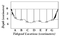
Example of one depth transect across the length
of a tidepool. Stations are separated by 20 centimeters
and labelled "A" through "G." |
Ecosystem Etiquette
Students should be dressed appropriately for the
conditions. They should NEVER work with their
backs to the water in the lower intertidal, keeping
waves in view. All organisms should be returned
to the location where they were found. All
disturbed rock, seaweed or other substrate should
be returned to its original position. Animals
should be treated with respect and care. Carry
in, carry out and make every effort to leave no trace! |
CROSS-CURRICULAR IDEAS
• Chemistry: What
is the relationship to the depth of the tidepool
and the salinity of the water?
• Physics/Mathematics: What
is the relationship between the depth of the tidepool
and the amount of water found in the pool? Take temperature
reading at various depths and graph temperature versus
depth.
• English/Language Arts: There
are many different life forms in tidepools. Pick
one and write a “day in the life of” story.
• Mathematics: Using
data collected in the field, have the students create
a class summation of the size of the tidepools studied
and number of species found. Create a class graph.
Is there any relation between the size and the number
of species? What about the size and other variables
such as temperature or salinity?
• Social Sciences: What
is the impact of human activity on tidepool areas?
• Physics/Mathematics/Biology: How
much force does a wave have? How do biological organisms
survive in areas of strong wave action? |
Assessment
Have students use cameras and camcorders to record
the tide pools. Back in the class room, have students
use their journal, along with the images, to construct
a visual map and identification of species found. Hold
a scientific conference on tidepools, where students
discuss their observations, as a group analyze the
data gathered, generate questions unanswered by their
data, and propose next steps in their investigation. |
Vocabulary
Depth gauge: a device to measure
depth.
Fauna: is the representative animal
or other life of a specific region. Fauna can also
be representative of a particular time because of
changing weather and climate conditions.
Flora: is the representative plant-life
of a specific region. Flora can also be representative
of a particular time because of changing weather
and climate conditions.
Tidepool: a tidepool is usually
found along a rocky coastal region. During high tide,
water covers a good portion of the coast. During
low tide, the water retreats to the sea. Tidepool
are small pools of water hidden between the rocks
left by the flowing tides. Tidepools serve as a refuge
for marine animals during low tide.
|
| Adapted from "Winds of Change" educational
CD-ROM, Copyright Caltech and NASA/Jet Propulsion Laboratory |
|
|