|
|
|
|
|
|
 |
<<
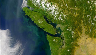
SeaWiFS satellite view of U.S. Pacific Northwest (courtesy of NASA) |
|
|
Satellites in orbit provide a better than "birds-eye"
view of our planet. Because of this perspective, satellites are extremely
useful for making large-scale measurements of the ocean. Remote sensing
is the term used to describe the process of making measurements from
a distance. Remote sensing and in situ ("in place") measurements
complement one another. With well-studied localized in situ measurements,
scientists can use satellite data to create comprehensive, calibrated
models of the ocean environment. Although the cost of building and launching
a satellite can be great, the amount of data obtained by such satellites
is so vast that the cost of individual data sets is often relatively small.
In addition, they provide global coverage which is crucial to understanding
the ocean environment. New computer, sensor, and electronic technologies
are further reducing the cost of building satellites, and satellite ocean
data are expected to become less expensive and even more powerful in the
future.
|
|
|
|
PHYTOPLANKTON, PIGMENTS & PHOTOSYNTHESIS
|
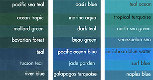 |
Using instruments that are more sensitive
than the human eye, we can measure carefully the wide array of colors of
the ocean; and if you think that the ocean is "just blue-green,"
check out the variety of blue-green colors at your local paint store (<<<).
From ocean color, we can infer information about phytoplankton populations.
Phytoplankton contain various colored pigments such as chlorophyll;
thus, ocean color signifies various types and geographic concentrations
of phytoplankton. Phytoplankton blooms -- the rapid growth of a phytoplankton
population -- are often marked by high concentrations of chlorophyll, a
chemical compound crucial for photosynthesis. Knowing the locations
of these blooms is very valuable to fishermen and marine biologists, because
fish and other marine animals tend to collect near fresh blooms. |
|
CHANGES IN OCEAN COLOR OVER TIME
|
| Comparing satellite images taken
at different periods tells us about changes that occur over time. Such satellite
instruments include NASA's Coastal Zone Color Scanner (CZCS) that
flew from 1978 to 1986, the Sea-viewing Wide Field-of-view Sensor (SeaWiFS)
which was launched in August 1997, and the Moderate Resolution Imaging Spectroradiometer
(MODIS) on the Earth Observing System's Terra satellite (launched
in December 1999). Data from these instruments are helping scientists discover
which phytoplankton species are involved in phytoplankton
blooms. |
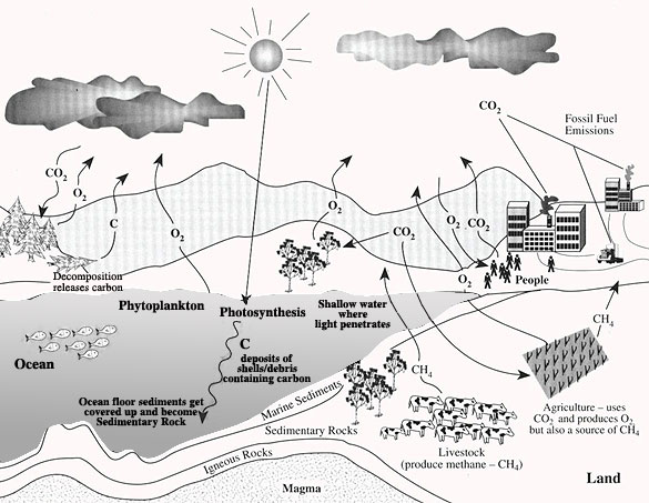
| Satellite-based ocean color data
are also helping to improve our understanding of the ocean's role in the
global carbon cycle. The atmosphere
is a rich source of carbon dioxide (CO2), as millions
of tons of this gas settle into the ocean every year. Phytoplankton use
sunlight and CO2 to make food and grow. When they
die, their bodies settle to the ocean bottom. Consequently, over geological
time, the ocean has become the primary storage sink for atmospheric
CO2. About 90 percent of the world's total carbon
content has settled to the bottom of the ocean, primarily in the form of
dead biomass. Click here to see a movie
about this process (2.1 MB, Courtesy Barbara Summey, NASA/Goddard Space
Flight Center) |
|
Some background material from NASA
Earth Observatory AND "Visit
to an Ocean Planet" CD-ROM, Copyright 1998, California Institute
of Technology and its licenses.
|
|
|
 |
|


