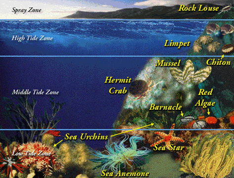
MAPPING THE DEPTH & POPULATION OF A TIDEPOOL

KEY CONCEPTS

  1. Tidepools are generally found on the exposed rock shelf below a sandy natural beach.
  2. The fauna and flora of tidepools must adapt to constant environmental changes caused by the incoming and outgoing tides.
 

MATERIALS

  • field trip to a tidepool area
  • 2 pieces of fishing line or twine, each 2 meters long
  • lead fishing weight or metal washer
  • meter stick
  • field journal
  • graph paper
  • tidepool organism identification chart (example provided below)


PROCEDURE


Activity

  1. Investigate an area with many tidepools. Split the class into groups.
  2. Locate a number of tidepools with varying depth (i.e., bottoms should not be flat).
    • For each tidepool, THE FIRST HALF OF THE GROUP should:
      1. Make a depth gauge by tying the weight or washer to one piece of the fishing line. This tool will be used to find the depth of various locations in the tidepool. Do not use the meter stick in the salt water. The paint will discolor or come off completely.
      2. Use a felt pen and divide the other piece of fishing line into 20 cm sections.
      3. Stretch the marked fishing line from one side of the tidepool to the other (to get the tidepool's length; see diagram below). This "guide line" across the tidepool is called a "transect."
      4. Using the weighted line, carefully drop the sink into the water at the first mark. This will be station "A". Allow the sink to touch the bottom of the pool. Pull the line until it is taut. Make sure that the sink is still touching the bottom.
      5. Hold the line at the surface of the water and pull it out of the water. Be sure not to move your fingers.
      6. Use the meter stick to measure the distance from the bottom of the sinker to the surface marking.
      7. Record the depth (cm) of station "A" in the field journal.
      8. Repeat steps 4 through 7 for each of the markings. Call the subsequent stations "B," "C," and so on.
      9. Once you have recorded the depth for all of the markings across the tidepool, repeat the same for the width of the tidepool.
      10. Use the graph paper to construct a depth chart. (Refer to sample chart)
      11. If the tidepool is relatively wide, you can make additional transects. Be careful to use different station labels for each transect.
    • For the same tidepool, THE SECOND HALF OF THE GROUP should:
      1. Identify and list as many organisms as possible. You can use the tidepool organism identification chart provided below. [CAUTION: Your tidepool's organisms may or may not be the same!]
      2. Using graph paper, draw the location of the organisms using the station labels that were chosen by the first half of the group.
      3. After the field trip, use the field notes to determine the population of each organism and their location within the tidepool.
      4. Construct a "pie chart" of the populations for each type of organism. Which had the greatest population? Did the organisms' locations correspond to certain depths within the tidepool?


Assessment Ideas

  • Have students use cameras and camcorders to record the tide pools. Back in the class room, have students use their journal , along with the images, to construct a visual map and identification of species found.


CROSS-CURRICULAR IDEAS

  • Chemistry: What is the relationship to the depth of the tidepool and the salinity of the water?
  • Physics/Mathematics: What is the relationship between the depth of the tidepool and the amount of water found in the pool? Take temperature reading at various depths and graph temperature versus depth.
  • English/Language Arts: There are many different life forms in tidepools. Pick one and write a ³day in the life of² story.
  • Mathematics: Using data collected in the field, have the students create a class summation of the size of the tidepools studied and number of species found. Create a class graph. Is there any relation between the size and the number of species? What about the size and other variables such as temperature or salinity?
  • Social Sciences: What is the impact of man on tidepool areas?
  • Physics/Mathematics/Biology: How much force does a wave have? How do biological organisms survive in areas of strong wave action?


VOCABULARY

  • depth gauge: a device to measure depth.
  • fauna: is the representative animal or other life of a specific region. Fauna can also be representative of a particular time because of changing weather and climate conditions.
  • flora: is the representative plant-life of a specific region. Flora can also be representative of a particular time because of changing weather and climate conditions.
  • tidepool: a tidepool is usually found along a rocky coastal region. During high tide, water covers a good portion of the coast. During low tide, the water retreats to the sea. Tidepool are small pools of water hidden between the rocks left by the flowing tides. Tidepools serve as a refuge for marine animals during low tide.


SOURCE

  • Adpated from "Winds of Change" educational CD-ROM, Copyright Caltech and NASA/Jet Propulsion Laboratory
 
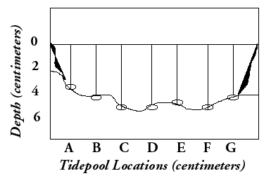
Example of one depth transect across the length of a tidepool. Stations are separated by 20 centimeters and labelled "A" through "G."

This rocky shore community has four zones whose placement is based on local tides. The spray zone is covered by water only during storms. The high tide zone is mostly dry, covered by the highest high tides but not reached by the lowest high tides. The middle tide zone is covered by all high tides and exposed during all low tides. The low tide zone, covered during the highest low tides, is exposed during the lowest low tides.

Mollusks, barnacles, and herbivorous sea gastropods are abundant. Just below the tidal zones, sponges, urchins, and anemones are very common where the light levels are low and current speeds are high. Firmly or permanently attached animals are often rich and diverse in caves and under boulders, where wave action is less.