|
|
CONCEPTS
- Sea level varies regionally with the seasons.
- In the mid-latitudes, seasonal sea level change is primarily controlled
by heating and cooling in the upper oceans.
- The TOPEX/Poseidon satellite measures global sea-level changes with
high accuracy. This allows oceanographers to observe seasonal changes
in the world's ocean surface. This has lead to an improved understanding
of the oceans' role in climate change.
- Water has a high heat capacity. This means
that it takes a lot of energy to heat or cool it (change its temperature).
Thus, the oceans heat and cool more slowly than the land or the atmosphere.
|
|
| |
MATERIALS
- Ocean Seasons image (provided below)
- World map with latitude information
- (optional) QuickTime animation installed on your computer
|
|
| |
PREPARATION
- The purpose of this activity is to stimulate a discussion about sea
surface height and the high heat capacity of water. It can be completed
in one of several ways. The way you choose to present the images may
depend upon the equipment available. You can use a computer screen to
display the color images (students can work in groups or individually
at the computer), or the images can be presented to the entire class
on a large monitor. Alternatively, you can print color versions for
students to work with, or print a color transparency to use on an overhead
projector.
- Students should be familiar with seasons and their cause before the
activity, or these topics can be covered or reviewed during the Engagement
section.
|
|
| |
PROCEDURE
|
|
Engagement
- Earth's obliquity -- the tilt of its
rotational axis relative to its orbit
-- causes us to experience four seasons each year: summer, fall,
winter, and spring. Timing of the seasons in the northern and
southern hemispheres are reversed. For example, summer in the
northern hemisphere occurs at the same time as winter in the southern
hemisphere.
- Click here to see an animation
about Earth's seasons.
- Be aware that this animation is 3.1 MB in size!
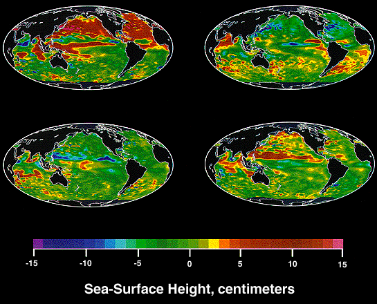
- Figure 1 shows how sea surface height
varies from its annual average from season to season. In this
activity you will analyze four satellite data maps and match them
to the season they represent. The images are derived from sea
level measurements made by Earth-orbiting TOPEX/Poseidon satellite
from September 1992 to August 1993.
- A clue for interpreting the images is that water has a very
high heat capacity, meaning that it takes a lot of energy transfer
to change its temperature, i.e., heat it up or cool it down. Thus,
the ocean heats and cools more slowly than land. You will use
this concept and your knowledge of the amount of solar heating
that occurs in each season, to determine which map is from fall,
winter, spring, and summer.
|
|
| |
Activity
- Observe all four images together. First, locate the land masses
on each image. You will need a map with latitude markings for
reference. Use this map to roughly sketch the equator and relevant
lines of latitude on each of the four images in Fig.
1. For this discussion, focus on the mid-latitudes in the
northern hemisphere (20°N - 50°N). You will need a map
with latitude markings for reference.
- Make sure that you are familiar with the color-coded sea surface
height scale for the images. In which image do you find the highest
sea surface heights? In which image do you find the lowest sea
surface heights? Explain your answers.
- Use your sea surface height observations to determine which
of the four images represents the sea levels from fall in the
northern hemisphere (spring in the southern hemisphere). Why did
you choose that image? How might the timing of the seasonal sea
level variations relate to the heat capacity of water?
- Once you have determined which image represents the fall in
the northern hemisphere, try to find the image that represents
summer. Why did you choose that image? How does sea surface height
compare between summer and fall? Finally, try to identify the
maps of north-ern hemisphere winter and spring. Explain your answers.
- Compare sea level responses in mid-latitudes in the northern
hemisphere with those in the southern hemisphere. Do they vary
in the same way? Which hemisphere has larger variations in sea
surface height? Can you guess why?
|
|
| |
Explanation
- Regional sea levels vary with the seasons. At mid-latitudes,
20° to 50° north and south, sea level change is controlled
by heating (which causes higher sea levels due to thermal expansion
of the water) and cooling in the upper ocean. In the northern
hemisphere fall, the temperature of the upper ocean layer and
sea level are high after being warmed throughout the summer. The
lowest sea levels occur in the northern hemisphere's spring.
- The southern hemisphere also experiences seasonal changes, but
to a lesser extent. One reason for this is that there is less
land in the southern hemisphere. This limits the extent of cold
winter air that blows out from continents to cool the oceans.
Moreover, the southern hemisphere has a greater proportion of
ocean to land, which results in a more moderate climate with less
seasonal change.
|
|
EXTENSION
- In the tropics (from about 20°N - 20°S latitude), sea level
is primarily controlled by wind. Bands of high and low sea level across
the Pacific and Atlantic Oceans correspond to changes in equatorial
currents. These equatorial currents shift in response to seasonal cycles
of the trade winds. The El Niño phenomenon,
which is triggered by an unusual "breakdown" of trade winds
in the western Pacific, affects ocean heat storage patterns. Discuss
the relationship between equatorial trade winds, sea level, heat storage,
and weather patterns during El Niño events.
- In the longer term, the oceans play an important role in determining
global climate. Discuss how data such as these can help scientists to
better understand patterns and changes in global climate.
|
|
| |
| These maps show variations in sea
level relative to the ocean's annual average height. Each image corresponds
to a different season. Effects of tides and gravity variations have
been removed. The sea surface height scale is provided on the image. |
 |
|
|
| |
VOCABULARY
- heat capacity: amount of heat required to raise the temperature
of a substance by a given amount.
- obliquity: deviation from parallel or perpendicular. The angle
between Earth's equator and orbit having a value of about 23°27'.
- orbit: the path a body makes revolving around an attracting
center of mass, as a planet around the Sun
- rotational axis: a line about which an object turns, spins,
or rotates. Earth's rotations axis is an imaginary line between the
North Pole and the South Pole.
- sea level: the level of the surface of the sea at its mean
position midway between mean high and low water.
- sea surface height: the height of the sea surface relative
to the center of Earth.
- trade winds: the air masses moving from subtropical high pressure
belts toward the equator. They are northeasterly in the Northern Hemisphere
and southeasterly in the Southern Hemisphere.
|
|
| |
SOURCE
- Adapted from "Visit to an Ocean Planet" educational CD-ROM,
Copyright Caltech and NASA/Jet Propulsion Laboratory
- San Juan Institute / Orange County Marine Institute Activity Series,
San Juan Capistrano, CA
|
|