|
|
MATERIALS
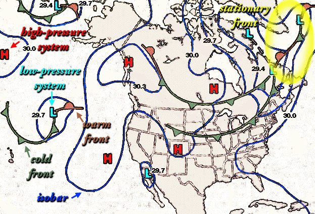
- sample weather map (provided below)
- current national weather maps collected over five days from a newspaper
indicating frontal activity
- map of the United States
|
|
| |
PROCEDURE
|
|
| |
|
|
Activity
- When a significant frontal system has been announced in weather
reports, start collecting current weather maps or satellite images
which indicate the front's direction of movement.
- Discuss the nature and classification of frontal systems. Also
discuss the use of symbols to represent
weather-related features.
- For the frontal system you and the students are following, discuss
where the cold and/or warm air originated. What type of weather
is found along the edge of the front as it moves along? Which
direction is the front moving?
- Locate low-pressure areas on weather maps where the fronts meet.
Is there a spiral movement of air (cyclone
or anticyclone) and if so, what direction
does the spiral move (clockwise or counterclockwise)?
- Once the direction of the front has been identified, try to
forecast weather for points (cities) along its path.
- Compare student forecasts with actual weather data as it becomes
available over a period several days.
|
|
| |
Assessment Ideas
- Students should record the passage of storm fronts using whatever
equipment is available. The means by which a student can identify
what has happened in the atmosphere and use data to document the
event can be used as an assessment product.
|
|
|
|
| |
CROSS-CURRICULAR IDEAS
- Mathematics/ Technology: Have students use probes and computers
or other equipment to chart various atmospheric conditions as a front
passes. What happens to wind direction and speed, barometric pressure,
temperature, relative humidity and cloud cover? Record and graph this
data over several days and several fronts.
- Art/Technology: Storms can very beautiful with striking images.
Use time lapse photography and tape the passage of a front. Use the
images to create scenes for use in cards or calendars. Store the images
electronically to form a bank of such images.
- Physics: Explain how lightning works. Record some time-lapse
records of lightning strikes as a summer front passes .
|
|
| |
VOCABULARY
- anticyclone: a high-pressure system in which winds flow outward
from the center, circulating clockwise in the Northern Hemisphere and
counterclockwise in the Southern Hemisphere
- cold front: the collision of air masses in which a cold air
mass overtakes a warm one, forcing the warm air to rise and causing
cumulus clouds to form.
- cyclone: a low-pressure system in which winds spiral inward
toward the center, circulating counterclockwise in the Northern Hemisphere
and clockwise in the Southern Hemisphere. A hurricane is an example
of a large warm tropical cyclone.
- front: the bounary between air masses with different temperature
and humidity characteristics.
- warm front: the collision of air masses in which warmer, less
dense air moves into an area of cold air over which it rises. Clouds
forms in layers and rain may occur.
|
|
| |
SOURCE
- Adapted from "Winds of Change" educational CD-ROM, Copyright
Caltech and NASA/Jet Propulsion Laboratory
|
|