READING & CREATING A WEATHER MAP

KEY CONCEPTS

  1. Standardized weather symbols represent such information as cold fronts, warm fronts, stationary fronts, isotherms, and isobars.
  2. By using these symbols, extensive meteorological information can be communicated effectively on a small weather map.
 

MATERIALS


PROCEDURE


Activity

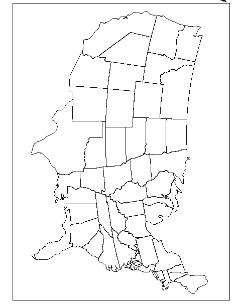
  1. Reproduce or print the black-and-white continental map. Distribute to each student.
  2. First, label the states on the map.
  3. Challenge students with good knowledge of United States geography to locate the regions known as the gulf states, Northern Plains, Rockies, California deserts.
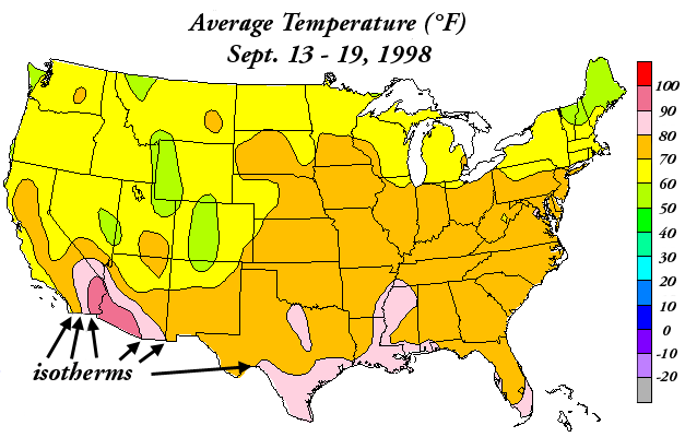
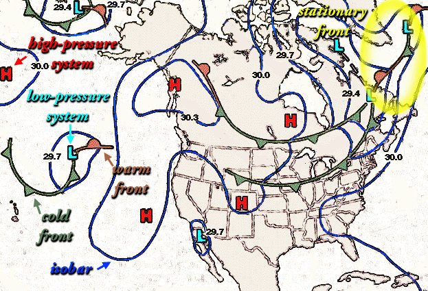
  4. Discuss how isotherms and isobars are used to show lines of constant readings. The sample temperature map and sample weather map can be used for this purpose.
  5. Using the sample weather map, introduce new weather symbols used to show cold fronts, warm fronts, stationary fronts, high-pressure, and low-pressure systems.
  6. Create scenarios for the students to symbolize on the map.
  7. Propose a number of weather conditions, including:
    • a warm front moving from Texas to gulf states
    • a cold front moving from Canada to the Northern Plains
    • warm temperatures into the 90s (indicated by an isotherm) from California deserts to southern Arizona
    • temperatures into the 80s (indicated by isotherms) from Los Angeles to San Francisco, into central Nevada, Arizona, Albuquerque and western Texas
    • temperatures into the 70s (indicated by an isotherm) from northern California to Oregon, central Idaho, Utah, Colorado, Missouri and north to Wisconsin.


Assessment Ideas

  • Have students create a series of weather maps in their science journals. The maps may be from new papers or other sources. Have the students label the maps with the weather conditions in particular cities and locations. Now pass out unlabeled satellite maps and have students label the main characteristics that they can identify. Create an overhead of either a labeled weather map or the satellite map. What correlation can be seen?


CROSS-CURRICULAR IDEAS

  • Art/Geography: Have students pick another area of the world to study the weather. Instead of using normal weather symbols, have students create their own symbols or icons that represent weather conditions. See if fellow students can guess or read the maps.
  • History/Social Science (Research Topic): What are the oldest weather symbols you can find? Who used them? Are any of the symbols still in use today? Are there new weather symbols being used today?
  • English/Art: Peter Spier has created an entire book on "Rain." The interesting aspect of the children's book is that there are no words. Using what ever images or art you need, construct a book that tells communicates weather without using words.


VOCABULARY

  • front: the zone where air masses of varying temperatures and moisture content collide. Storms typically occur along front lines where the air masses meet.
  • isobar: a line on a map that connects points of equal air pressure.
  • isotherm: a line on a map that connects points of equal temperature.
  • stationary front: where cold and warm air masses are in balance and thus barely move over the course of a day or so.


SOURCE

  • Adpated from "Winds of Change" educational CD-ROM, Copyright Caltech and NASA/Jet Propulsion Laboratory
 
  • isotherms: lines that connect points with the same temperature reading. They are seen on this map as the black lines that separate different colors. The scale at right shows the degrees in Fahrenheit that each isotherm represents. [Map is from: the National Oceanic and Atmospheric Administration (NOAA) National Center for Environmental Prediction (NCEP) Climate Prediction Center http://nic.fb4.noaa.gov/]
  • isobar (dark blue, lower left): lines that connect points with the same barometric pressure reading. The black numbers -- 29.4, 29.7, 30.0, 30.3 -- show the barometric pressure value (in inches) at sea level.
  • high-pressure system (red "H," upper left): wind circulates clockwise around high-pressure systems in the northern hemisphere (opposite in the southern hemisphere)
  • high-pressure system (light blue "L," middle left): wind circulates counterclockwise around low-pressure systems in the northern hemisphere (opposite in the southern hemisphere)
  • cold front (green line with triangles, lower left): The triangles point in the direction toward which the cold front is moving.
  • warm front (brown line with semi-circles, middle left): The semicircles point in the direction toward which the warm front is moving.
  • stationary front (yellow circle around line with brown semicircles and green triangles, upper right): These are shown on weather maps as alternating triangles and semicircles.
Map of continental United States