Helpful
Hints
For
each "Hatch Area" you will see animated data showing your cohort's
path, surface water temperatures, speed and the "Larvae Count."
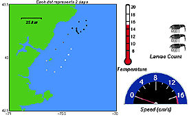

For each area where you might wish to settle your cohort, you will see a screen similar to this (<<<):
To PRINT THE DATA SHEET FOR ANY AREA, click on the "PRINT DATA" button (marked by red arrows in this example).
WHILE VIEWING ANIMATIONS OF YOUR COHORT TRAVELING IN THE GULF OF MAINE:
- How long after hatch did your cohort reach Stage 2, Stage 3, Stage 4? What is controlling these growth rates?
- About how fast do currents move in the Gulf of Maine? Do these rates vary from place-to-place?
- For each area, is there a tie between the number of settlers and the amount of time they spent drifting in the Gulf? Why or why not?
WHILE DECIDING WHETHER OR NOT TO SETTLE AT A CERTAIN SPOT:
- Is the depth where my cohort settles important? Why or why not?
- Will the temperature where they settle affect their growth rates? Why might faster-growing lobsters have a better chance of succeeding?
- What kind of predators might be around? What is your cohort's best defense against predators?
- Can Stage 4 (in other words, "ready to settle") lobsters DECIDE where they might want to settle? How might they do this?