
|
Food chains vary among different
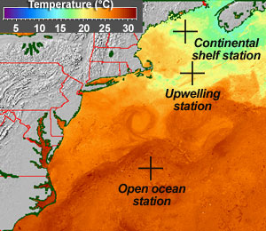
marine habitats. Classic habitat types include the open ocean,
upwelling regions, and continental shelves. At right
(>>), a typical open ocean food chain is shown.
|
||
|
Roll your cursor over station locations (<<) to see typical food chains for those regions (>>). How do these food chains vary? What factors influence this variation in food chain types? Two complementary data sets are sea surface temperature (<<) and ocean color; the latter is surface primary productivity measured as chlorophyll. Use your cursor to toggle between these maps. How do the patterns compare? Also, how does ocean color relate to the number of trophic levels within various food chains? |
|
| Temperature data from Johns Hopkins U. Applied Physics Laboratory | ||
| Ocean color data from NASA | ||
 |
 |
 |
 |
 |
 |